Sake night lights from space
Night Light of Sake (Nord Kivu) from space (Democratic Republic of the Congo) Src. Average luminocity for 10x10km area is 1.2208% and for 50x50km: 1.9995%.
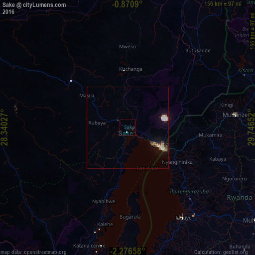
Analysis of Sake night lights 2016
Square area 10x10 km:
 0%
0%90-99
0.87%80-89
0%70-79
0%60-69
0%50-59
0%40-49
0%30-39
0.87%20-29
0%10-19
0%0-9
98.27%Square area 50x50 km:
0.29%90-99
0.33%80-89
0.15%70-79
0.18%60-69
0.32%50-59
0.29%40-49
0.12%30-39
0.57%20-29
0.28%10-19
0.83%0-9
96.64%Clear (daylight) street map image can be seen on geolist.org.
Map coordinates:
0° 52' 15.2" South, 28° 20' 25" East
1° 34' 25.9" South, 29° 2' 36.2" East
2° 16' 35.7" South, 29° 44' 47.5" East
Some cities around Sake sort by population:
• Goma
23.4 km =14.5 mi,  118°
118°
• Gitarama, RW
96.9 km =60.2 mi,  125°
125°
• Musanze, RW
66.3 km =41.2 mi,  82°
82°
• Gisenyi, RW
27.7 km =17.2 mi, 121°
• Cyangugu, RW
102.4 km =63.6 mi,  188°
188°
• Kibuye, RW
63.8 km =39.6 mi,  147°
147°
• Ntungamo, UG
102.2 km =63.5 mi,  41°
41°
• Kisoro, UG
78.2 km =48.6 mi,  65°
65°
205970 (p: 17,151)
Sources (retrieved 2019-11-25):
» Earth at Night: Flat Maps 2012, 2016