West Kelowna night lights from space
Night Light of West Kelowna (British Columbia) from space (Canada) Src. Average luminocity for 10x10km area is 39.7086% and for 50x50km: 7.1042%.
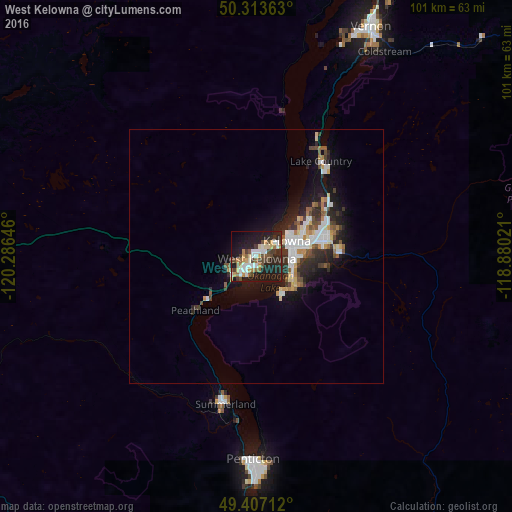

Analysis of West Kelowna night lights 2016
Square area 10x10 km:
 5.75%
5.75%90-99
6.68%80-89
3.34%70-79
6.28%60-69
4.55%50-59
4.68%40-49
8.02%30-39
4.41%20-29
16.84%10-19
32.75%0-9
6.68%Square area 50x50 km:
1.28%90-99
1.26%80-89
0.62%70-79
0.7%60-69
0.73%50-59
0.8%40-49
1.01%30-39
1.06%20-29
2.51%10-19
5.19%0-9
84.83%Clear (daylight) street map image can be seen on geolist.org.
Map coordinates:
50° 18' 49.1" North, 120° 17' 11.3" West
49° 51' 45" North, 119° 34' 60" West
49° 24' 25.6" North, 118° 52' 48.8" West
Some cities around West Kelowna sort by population:
• Okanagan
58.2 km =36.2 mi,  16°
16°
• Kelowna
7.4 km =4.6 mi,  71°
71°
• Vernon
50.2 km =31.2 mi,  26°
26°
• Penticton
42.5 km =26.4 mi,  180°
180°
• Merritt
90.9 km =56.5 mi,  287°
287°
• Duck Lake
21 km =13 mi,  39°
39°
• Summerland
29.9 km =18.6 mi,  191°
191°
• Oliver
75.6 km =47 mi, 178°
7281936 (p: 28,793)
Sources (retrieved 2019-11-25):
» Earth at Night: Flat Maps 2012, 2016