Uxbridge night lights from space
Night Light of Uxbridge (Ontario) from space (Canada) Src. Average luminocity for 10x10km area is 7.8409% and for 50x50km: 15.5308%.
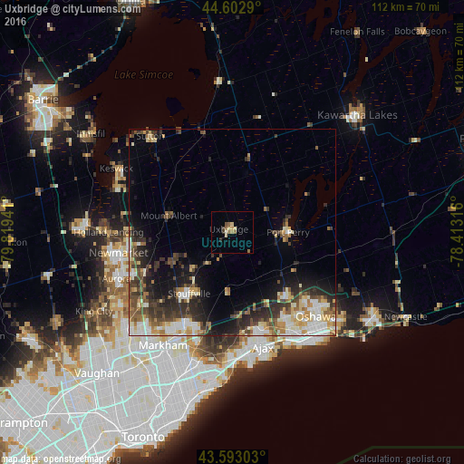
Analysis of Uxbridge night lights 2016
Square area 10x10 km:
 0%
0%90-99
0.61%80-89
2.42%70-79
0.61%60-69
1.67%50-59
2.12%40-49
1.06%30-39
0.61%20-29
0.61%10-19
0%0-9
90.3%Square area 50x50 km:
2.22%90-99
3.02%80-89
2.05%70-79
1.75%60-69
1.83%50-59
2.01%40-49
2.83%30-39
3.07%20-29
4.35%10-19
6.07%0-9
70.8%Clear (daylight) street map image can be seen on geolist.org.
Map coordinates:
44° 36' 10.4" North, 79° 49' 9.9" West
44° 6' 0.4" North, 79° 6' 58.6" West
43° 35' 34.9" North, 78° 24' 47.4" West
Some cities around Uxbridge sort by population:
• Oshawa
30.8 km =19.1 mi,  136°
136°
• Markham
28.6 km =17.8 mi,  204°
204°
• Ajax
28.6 km =17.8 mi,  166°
166°
• Pickering
22.3 km =13.9 mi,  183°
183°
• Newmarket
28.5 km =17.7 mi,  258°
258°
• Aurora
30.1 km =18.7 mi,  248°
248°
• East Gwillimbury
25.7 km =16 mi,  270°
270°
• Keswick
32.5 km =20.2 mi,  300°
300°
6172932 (p: 11,531)
Sources (retrieved 2019-11-25):
» Earth at Night: Flat Maps 2012, 2016