Sechelt night lights from space
Night Light of Sechelt (British Columbia) from space (Canada) Src. Average luminocity for 10x10km area is 3.3838% and for 50x50km: 0.5005%.
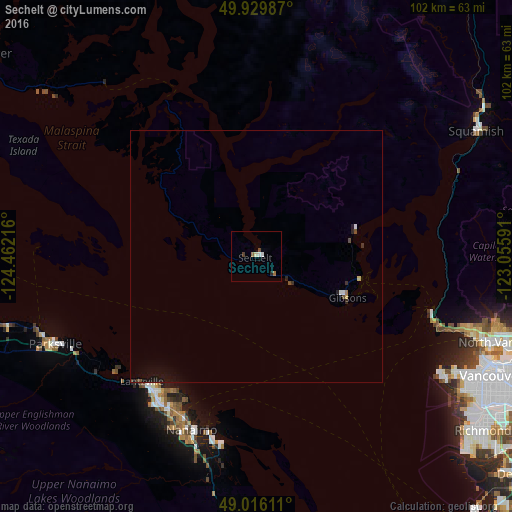
Analysis of Sechelt night lights 2016
Square area 10x10 km:
 0.56%
0.56%90-99
0.56%80-89
0.56%70-79
0%60-69
1.12%50-59
0.14%40-49
0.7%30-39
0.28%20-29
0.56%10-19
0%0-9
95.52%Square area 50x50 km:
0.06%90-99
0.06%80-89
0.07%70-79
0%60-69
0.07%50-59
0.03%40-49
0.1%30-39
0.1%20-29
0.12%10-19
0.38%0-9
99.02%Clear (daylight) street map image can be seen on geolist.org.
Map coordinates:
49° 55' 47.5" North, 124° 27' 43.8" West
49° 28' 30.4" North, 123° 45' 32.5" West
49° 0' 58" North, 123° 3' 21.3" West
Some cities around Sechelt sort by population:
• Vancouver
52.7 km =32.7 mi,  118°
118°
• Nanaimo
36.7 km =22.8 mi,  200°
200°
• North Vancouver
52.9 km =32.9 mi,  109°
109°
• West End
50.1 km =31.1 mi, 115°
• West Vancouver
44.5 km =27.7 mi, 105°
• Squamish
50.1 km =31.1 mi,  60°
60°
• Parksville
43.8 km =27.2 mi,  246°
246°
• Gibsons
20.4 km =12.7 mi, 115°
6143367 (p: 8,832)
Sources (retrieved 2019-11-25):
» Earth at Night: Flat Maps 2012, 2016