Salt Spring Island night lights from space
Night Light of Salt Spring Island (British Columbia) from space (Canada) Src. Average luminocity for 10x10km area is 1.2372% and for 50x50km: 2.1085%.
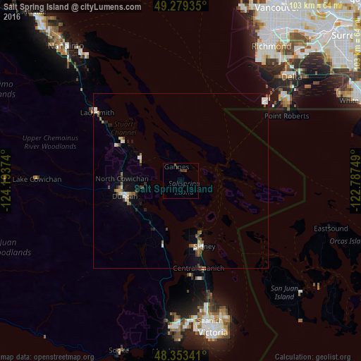
Analysis of Salt Spring Island night lights 2016
Square area 10x10 km:
 0%
0%90-99
0%80-89
0%70-79
0%60-69
0%50-59
0.57%40-49
0.85%30-39
1.28%20-29
0.14%10-19
0%0-9
97.16%Square area 50x50 km:
0.32%90-99
0.3%80-89
0.23%70-79
0.13%60-69
0.25%50-59
0.38%40-49
0.3%30-39
0.33%20-29
0.15%10-19
0.67%0-9
96.96%Clear (daylight) street map image can be seen on geolist.org.
Map coordinates:
49° 16' 45.7" North, 124° 11' 37.5" West
48° 49' 6.7" North, 123° 29' 26.2" West
48° 21' 12.3" North, 122° 47' 15" West
Some cities around Salt Spring Island sort by population:
• Ladner
42.4 km =26.3 mi,  44°
44°
• North Cowichan
14.5 km =9 mi,  280°
280°
• Langford
41 km =25.5 mi,  181°
181°
• Duncan
16 km =9.9 mi,  255°
255°
• Tsawwassen
37 km =23 mi,  53°
53°
• Colwood
42.9 km =26.7 mi, 179°
• North Saanich
17.7 km =11 mi,  162°
162°
• Ladysmith
30.5 km =19 mi,  308°
308°
12042098 (p: 10,557)
Sources (retrieved 2019-11-25):
» Earth at Night: Flat Maps 2012, 2016