Sainte-Marie night lights from space
Night Light of Sainte-Marie (Quebec) from space (Canada) Src. Average luminocity for 10x10km area is 20.244% and for 50x50km: 3.174%.
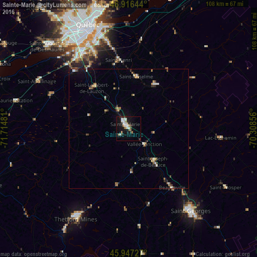
Analysis of Sainte-Marie night lights 2016
Square area 10x10 km:
 3.57%
3.57%90-99
5.95%80-89
1.19%70-79
0%60-69
3.72%50-59
2.08%40-49
1.04%30-39
1.49%20-29
1.93%10-19
20.68%0-9
58.33%Square area 50x50 km:
0.27%90-99
0.56%80-89
0.33%70-79
0.25%60-69
0.5%50-59
0.48%40-49
0.42%30-39
0.39%20-29
0.46%10-19
1.67%0-9
94.67%Clear (daylight) street map image can be seen on geolist.org.
Map coordinates:
46° 54' 59.2" North, 71° 42' 53.3" West
46° 26' 2.4" North, 71° 0' 42" West
45° 56' 50.2" North, 70° 18' 30.8" West
Some cities around Sainte-Marie sort by population:
• Québec
44.8 km =27.8 mi,  339°
339°
• Lévis
43 km =26.7 mi, 342°
• La Haute-Saint-Charles
57.7 km =35.9 mi,  331°
331°
• Thetford-Mines
44.1 km =27.4 mi,  210°
210°
• L'Ancienne-Lorette
47.7 km =29.6 mi, 327°
• Plessisville
62.4 km =38.8 mi,  247°
247°
• Beauceville
30 km =18.6 mi,  143°
143°
• Donnacona
61 km =37.9 mi,  296°
296°
6945989 (p: 11,584)
Sources (retrieved 2019-11-25):
» Earth at Night: Flat Maps 2012, 2016