Saint-Zotique night lights from space
Night Light of Saint-Zotique (Quebec) from space (Canada) Src. Average luminocity for 10x10km area is 17.1045% and for 50x50km: 9.2775%.
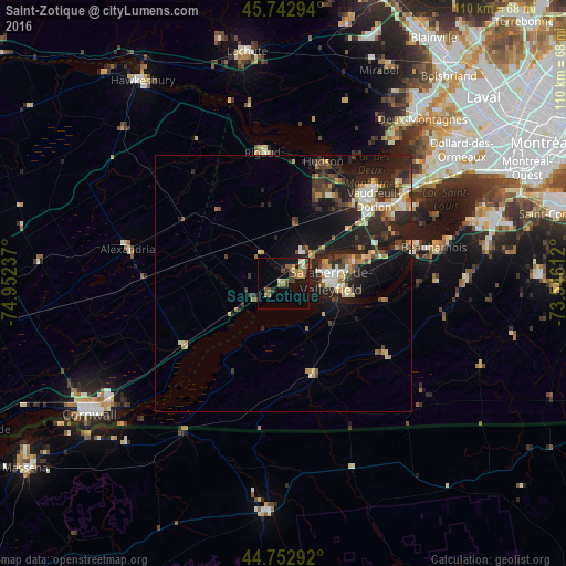
Analysis of Saint-Zotique night lights 2016
Square area 10x10 km:
 0.3%
0.3%90-99
2.12%80-89
0.61%70-79
2.88%60-69
5.3%50-59
3.18%40-49
3.33%30-39
1.67%20-29
2.12%10-19
14.85%0-9
63.64%Square area 50x50 km:
0.9%90-99
1.33%80-89
1.02%70-79
1.16%60-69
1.24%50-59
0.88%40-49
1.55%30-39
1.97%20-29
4.27%10-19
7.67%0-9
78.01%Clear (daylight) street map image can be seen on geolist.org.
Map coordinates:
45° 44' 34.6" North, 74° 57' 8.5" West
45° 15' 0.3" North, 74° 14' 57.3" West
44° 45' 10.5" North, 73° 32' 46" West
Some cities around Saint-Zotique sort by population:
• Salaberry-de-Valleyfield
9.1 km =5.7 mi,  90°
90°
• Vaudreuil-Dorion
23.8 km =14.8 mi,  45°
45°
• Les Coteaux
3.9 km =2.4 mi,  19°
19°
• Pincourt
25.6 km =15.9 mi, 54°
• L'Île-Perrot
27.7 km =17.2 mi,  57°
57°
• Notre-Dame-de-l'Île-Perrot
28 km =17.4 mi, 62°
• Coteau-du-Lac
7.6 km =4.7 mi,  43°
43°
• Hudson
23.6 km =14.7 mi, 19°
6139216 (p: 6,773)
Sources (retrieved 2019-11-25):
» Earth at Night: Flat Maps 2012, 2016