Notre-Dame-de-l'Île-Perrot night lights from space
Night Light of Notre-Dame-de-l'Île-Perrot (Quebec) from space (Canada) Src. Average luminocity for 10x10km area is 36.5746% and for 50x50km: 32.9606%.
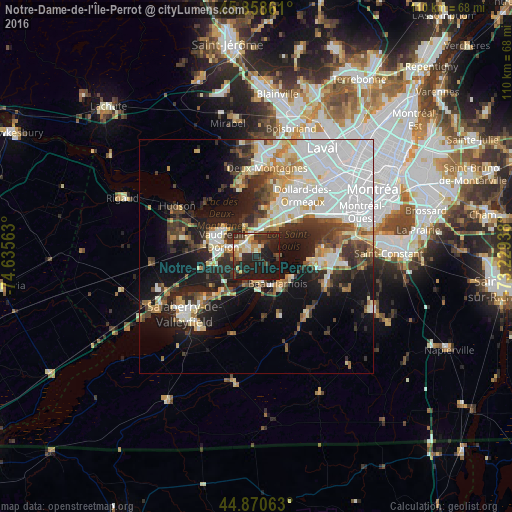
Analysis of Notre-Dame-de-l'Île-Perrot night lights 2016
Square area 10x10 km:
 2.06%
2.06%90-99
7.14%80-89
3.33%70-79
6.03%60-69
3.97%50-59
2.7%40-49
4.6%30-39
8.25%20-29
26.03%10-19
35.4%0-9
0.48%Square area 50x50 km:
10.88%90-99
6.17%80-89
2.94%70-79
3.09%60-69
3.04%50-59
2.48%40-49
3.57%30-39
4.91%20-29
7.71%10-19
13.93%0-9
41.27%Clear (daylight) street map image can be seen on geolist.org.
Map coordinates:
45° 51' 31" North, 74° 38' 8.3" West
45° 22' 0.4" North, 73° 55' 57" West
44° 52' 14.3" North, 73° 13' 45.8" West
Some cities around Notre-Dame-de-l'Île-Perrot sort by population:
• Pointe-Claire
12.8 km =8 mi,  44°
44°
• Vaudreuil-Dorion
8.6 km =5.3 mi,  295°
295°
• Kirkland
10.6 km =6.6 mi,  29°
29°
• Beaconsfield
9.1 km =5.7 mi, 35°
• Beauharnois
7.6 km =4.7 mi,  141°
141°
• Pincourt
4.3 km =2.7 mi, 295°
• L'Île-Perrot
2.3 km =1.4 mi,  324°
324°
• Sainte-Anne-de-Bellevue
4.5 km =2.8 mi,  346°
346°
6091369 (p: 9,885)
Sources (retrieved 2019-11-25):
» Earth at Night: Flat Maps 2012, 2016