Les Coteaux night lights from space
Night Light of Les Coteaux (Quebec) from space (Canada) Src. Average luminocity for 10x10km area is 23.0032% and for 50x50km: 10.6188%.
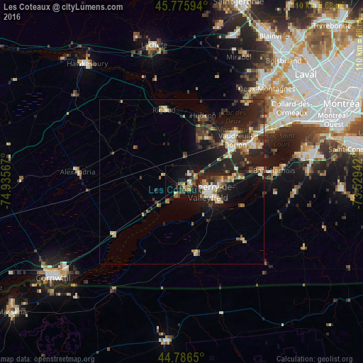
Analysis of Les Coteaux night lights 2016
Square area 10x10 km:
 2.06%
2.06%90-99
2.38%80-89
0.63%70-79
3.17%60-69
6.19%50-59
3.81%40-49
5.24%30-39
2.54%20-29
5.4%10-19
25.87%0-9
42.7%Square area 50x50 km:
1%90-99
1.51%80-89
1.22%70-79
1.36%60-69
1.32%50-59
1.03%40-49
1.78%30-39
2.41%20-29
4.9%10-19
8.45%0-9
75.02%Clear (daylight) street map image can be seen on geolist.org.
Map coordinates:
45° 46' 33.4" North, 74° 56' 8.4" West
45° 17' 0.2" North, 74° 13' 57.1" West
44° 47' 11.4" North, 73° 31' 45.9" West
Some cities around Les Coteaux sort by population:
• Salaberry-de-Valleyfield
8.7 km =5.4 mi,  115°
115°
• Vaudreuil-Dorion
20.3 km =12.6 mi,  50°
50°
• Saint-Lazare
15.1 km =9.4 mi,  31°
31°
• Pincourt
22.5 km =14 mi,  60°
60°
• L'Île-Perrot
24.8 km =15.4 mi, 63°
• Coteau-du-Lac
4.3 km =2.7 mi, 64°
• Saint-Zotique
3.9 km =2.4 mi,  199°
199°
• Hudson
19.6 km =12.2 mi,  19°
19°
6052788 (p: 17,396)
Sources (retrieved 2019-11-25):
» Earth at Night: Flat Maps 2012, 2016