Saint-Rémi night lights from space
Night Light of Saint-Rémi (Quebec) from space (Canada) Src. Average luminocity for 10x10km area is 19.1652% and for 50x50km: 24.8476%.
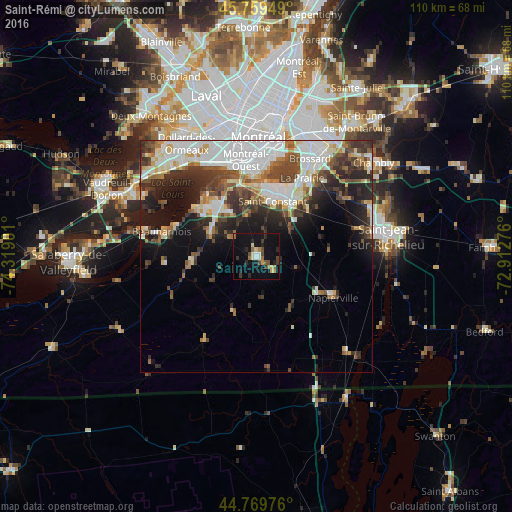
Analysis of Saint-Rémi night lights 2016
Square area 10x10 km:
 1.21%
1.21%90-99
2.12%80-89
1.97%70-79
1.97%60-69
3.03%50-59
2.42%40-49
3.03%30-39
3.33%20-29
4.7%10-19
25%0-9
51.21%Square area 50x50 km:
6.52%90-99
5.38%80-89
2.05%70-79
2.15%60-69
2.42%50-59
2.67%40-49
4.05%30-39
4.3%20-29
6.02%10-19
8.74%0-9
55.71%Clear (daylight) street map image can be seen on geolist.org.
Map coordinates:
45° 45' 34.2" North, 74° 19' 8.4" West
45° 16' 0.4" North, 73° 36' 57.2" West
44° 46' 11.1" North, 72° 54' 45.9" West
Some cities around Saint-Rémi sort by population:
• Châteauguay
16.6 km =10.3 mi,  321°
321°
• Côte-Saint-Luc
22.4 km =13.9 mi,  349°
349°
• La Prairie
19 km =11.8 mi,  28°
28°
• Candiac
15.1 km =9.4 mi, 31°
• Beauharnois
20.7 km =12.9 mi,  284°
284°
• Mercier
11.8 km =7.3 mi,  298°
298°
• Delson
12.3 km =7.6 mi, 25°
• Montréal-Ouest
20.9 km =13 mi, 352°
6138987 (p: 6,891)
Sources (retrieved 2019-11-25):
» Earth at Night: Flat Maps 2012, 2016