Châteauguay night lights from space
Night Light of Châteauguay (Quebec) from space (Canada) Src. Average luminocity for 10x10km area is 50.8873% and for 50x50km: 45.6015%.
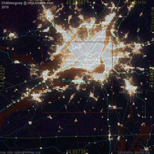

Analysis of Châteauguay night lights 2016
Square area 10x10 km:
 6.83%
6.83%90-99
10%80-89
5.4%70-79
7.14%60-69
6.98%50-59
5.24%40-49
11.9%30-39
17.46%20-29
16.98%10-19
12.06%0-9
0%Square area 50x50 km:
18.92%90-99
10.04%80-89
3.43%70-79
3.67%60-69
3.3%50-59
2.81%40-49
4.36%30-39
4.59%20-29
7.15%10-19
11.43%0-9
30.29%Clear (daylight) street map image can be seen on geolist.org.
Map coordinates:
45° 52' 30.3" North, 74° 27' 8.4" West
45° 23' 0.2" North, 73° 44' 57.1" West
44° 53' 14.6" North, 73° 2' 45.9" West
Some cities around Châteauguay sort by population:
• Côte-Saint-Luc
11.2 km =7 mi,  35°
35°
• Pointe-Claire
9 km =5.6 mi,  324°
324°
• Kirkland
11.7 km =7.3 mi,  309°
309°
• Beaconsfield
10.7 km =6.6 mi,  301°
301°
• Dorval
7.1 km =4.4 mi,  357°
357°
• Beauharnois
12.4 km =7.7 mi,  231°
231°
• Mercier
7.4 km =4.6 mi,  180°
180°
• Montréal-Ouest
11 km =6.8 mi,  45°
45°
5920433 (p: 42,786)
Sources (retrieved 2019-11-25):
» Earth at Night: Flat Maps 2012, 2016