Montréal-Ouest night lights from space
Night Light of Montréal-Ouest (Quebec) from space (Canada) Src. Average luminocity for 10x10km area is 91.8841% and for 50x50km: 57.5567%.
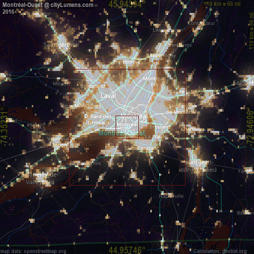
Analysis of Montréal-Ouest night lights 2016
Square area 10x10 km:
 66.67%
90-99
13.02%80-89
3.97%70-79
1.43%60-69
5.87%50-59
2.86%40-49
5.71%30-39
0.48%20-29
0%10-19
0%0-9
0%Square area 50x50 km:
22.69%90-99
13.53%80-89
4.26%70-79
5.53%60-69
5.05%50-59
4.8%40-49
5.82%30-39
5.42%20-29
7.07%10-19
9.93%0-9
15.92%Clear (daylight) street map image can be seen on geolist.org.
Map coordinates:
45° 56' 38.2" North, 74° 21' 8.3" West
45° 27' 10.3" North, 73° 38' 57" West
44° 57' 26.9" North, 72° 56' 45.8" West
Some cities around Montréal-Ouest sort by population:
• Saint-Laurent
5.4 km =3.4 mi,  346°
346°
• Notre-Dame-de-Grâce
3.8 km =2.4 mi,  45°
45°
• Côte-Saint-Luc
1.9 km =1.2 mi,  316°
316°
• Westmount
5.2 km =3.2 mi, 48°
• Mont-Royal
7.1 km =4.4 mi,  0°
0°
• Dorval
8.1 km =5 mi,  265°
265°
• Sainte-Catherine
7.8 km =4.8 mi,  138°
138°
• Hampstead
3.3 km =2.1 mi,  340°
340°
6077265 (p: 5,184)
Sources (retrieved 2019-11-25):
» Earth at Night: Flat Maps 2012, 2016