Saint-Lazare night lights from space
Night Light of Saint-Lazare (Quebec) from space (Canada) Src. Average luminocity for 10x10km area is 25.6968% and for 50x50km: 19.2738%.
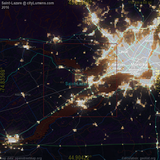
Analysis of Saint-Lazare night lights 2016
Square area 10x10 km:
 0.48%
0.48%90-99
1.43%80-89
0.79%70-79
3.17%60-69
1.27%50-59
4.13%40-49
8.89%30-39
14.13%20-29
12.7%10-19
31.11%0-9
21.9%Square area 50x50 km:
2.65%90-99
3.48%80-89
2.45%70-79
2.68%60-69
2.42%50-59
1.8%40-49
2.76%30-39
3.6%20-29
6.43%10-19
11.8%0-9
59.93%Clear (daylight) street map image can be seen on geolist.org.
Map coordinates:
45° 53' 29.8" North, 74° 50' 8.5" West
45° 24' 0.3" North, 74° 7' 57.2" West
44° 54' 15.2" North, 73° 25' 46" West
Some cities around Saint-Lazare sort by population:
• Salaberry-de-Valleyfield
16.7 km =10.4 mi,  179°
179°
• Vaudreuil-Dorion
7.8 km =4.8 mi,  90°
90°
• Les Coteaux
15.1 km =9.4 mi,  211°
211°
• Pincourt
11.9 km =7.4 mi,  99°
99°
• L'Île-Perrot
14.4 km =8.9 mi, 97°
• Notre-Dame-de-l'Île-Perrot
16.1 km =10 mi, 103°
• Coteau-du-Lac
11.8 km =7.3 mi,  199°
199°
• Hudson
5.7 km =3.5 mi,  346°
346°
6138617 (p: 17,016)
Sources (retrieved 2019-11-25):
» Earth at Night: Flat Maps 2012, 2016