Paris night lights from space
Night Light of Paris (Ontario) from space (Canada) Src. Average luminocity for 10x10km area is 19.6045% and for 50x50km: 12.8505%.
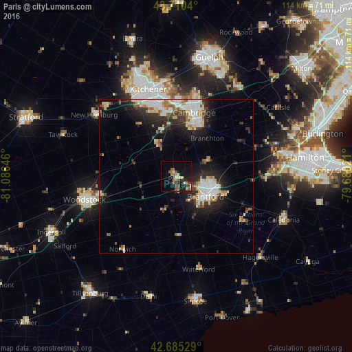
Analysis of Paris night lights 2016
Square area 10x10 km:
 1.06%
1.06%90-99
3.03%80-89
1.97%70-79
0.61%60-69
4.85%50-59
3.79%40-49
3.33%30-39
1.67%20-29
5.45%10-19
19.24%0-9
55%Square area 50x50 km:
2.33%90-99
2.91%80-89
1.46%70-79
0.98%60-69
1.43%50-59
1.28%40-49
1%30-39
1.71%20-29
4.39%10-19
7.67%0-9
74.82%Clear (daylight) street map image can be seen on geolist.org.
Map coordinates:
43° 42' 37.4" North, 81° 5' 11.3" West
43° 12' 0" North, 80° 22' 60" West
42° 41' 7" North, 79° 40' 48.8" West
Some cities around Paris sort by population:
• Kitchener
27.1 km =16.8 mi,  337°
337°
• Cambridge
18.7 km =11.6 mi,  17°
17°
• Waterloo
31.6 km =19.6 mi, 340°
• Brantford
12 km =7.5 mi,  127°
127°
• Woodstock
30.6 km =19 mi,  256°
256°
• Brant
7.9 km =4.9 mi,  159°
159°
• Ancaster
32.2 km =20 mi,  86°
86°
• New Hamburg
32.7 km =20.3 mi,  308°
308°
6942553 (p: 11,177)
Sources (retrieved 2019-11-25):
» Earth at Night: Flat Maps 2012, 2016