Notre-Dame-des-Prairies night lights from space
Night Light of Notre-Dame-des-Prairies (Quebec) from space (Canada) Src. Average luminocity for 10x10km area is 45.4403% and for 50x50km: 9.4196%.
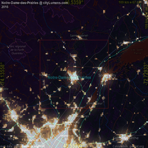
Analysis of Notre-Dame-des-Prairies night lights 2016
Square area 10x10 km:
 12.07%
90-99
12.5%80-89
4.97%70-79
2.84%60-69
2.13%50-59
5.11%40-49
1.28%30-39
2.27%20-29
18.47%10-19
31.68%0-9
6.68%Square area 50x50 km:
0.96%90-99
1.46%80-89
1.12%70-79
0.76%60-69
1.12%50-59
1.38%40-49
1.27%30-39
1.33%20-29
2.81%10-19
6.87%0-9
80.92%Clear (daylight) street map image can be seen on geolist.org.
Map coordinates:
46° 32' 9.2" North, 74° 8' 8.1" West
46° 3' 0.3" North, 73° 25' 56.8" West
45° 33' 35.7" North, 72° 43' 45.6" West
Some cities around Notre-Dame-des-Prairies sort by population:
• Repentigny
34.3 km =21.3 mi,  182°
182°
• Sorel-Tracy
24.6 km =15.3 mi,  92°
92°
• Joliette
3.8 km =2.4 mi,  169°
169°
• L'Assomption
25.2 km =15.7 mi, 179°
• Saint-Lin-Laurentides
34 km =21.1 mi,  229°
229°
• Lavaltrie
21.9 km =13.6 mi,  147°
147°
• Saint-Félix-de-Valois
13.3 km =8.3 mi,  2°
2°
• Rawdon
21.9 km =13.6 mi,  270°
270°
6091422 (p: 8,230)
Sources (retrieved 2019-11-25):
» Earth at Night: Flat Maps 2012, 2016