Saint-Lin-Laurentides night lights from space
Night Light of Saint-Lin-Laurentides (Quebec) from space (Canada) Src. Average luminocity for 10x10km area is 14.5893% and for 50x50km: 26.644%.
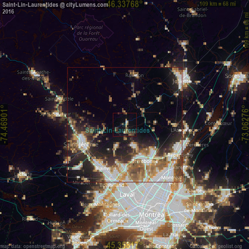
Analysis of Saint-Lin-Laurentides night lights 2016
Square area 10x10 km:
 0.3%
0.3%90-99
0.45%80-89
1.93%70-79
0.6%60-69
3.13%50-59
2.38%40-49
2.68%30-39
5.95%20-29
1.93%10-19
11.16%0-9
69.49%Square area 50x50 km:
4.69%90-99
5.3%80-89
2.67%70-79
2.94%60-69
3.7%50-59
4.06%40-49
4.17%30-39
4.18%20-29
7.95%10-19
10.84%0-9
49.5%Clear (daylight) street map image can be seen on geolist.org.
Map coordinates:
46° 20' 15.6" North, 74° 28' 8.4" West
45° 51' 0.3" North, 73° 45' 57.2" West
45° 21' 29.4" North, 73° 3' 45.9" West
Some cities around Saint-Lin-Laurentides sort by population:
• Terrebonne
19 km =11.8 mi,  151°
151°
• Blainville
22.3 km =13.9 mi,  203°
203°
• Mascouche
17.1 km =10.6 mi,  130°
130°
• Rosemère
24.2 km =15 mi,  186°
186°
• Prévost
24.6 km =15.3 mi,  274°
274°
• Lorraine
18.6 km =11.6 mi,  183°
183°
• Bois-des-Filion
20.4 km =12.7 mi, 176°
• Rawdon
22.6 km =14 mi,  9°
9°
6138643 (p: 14,159)
Sources (retrieved 2019-11-25):
» Earth at Night: Flat Maps 2012, 2016