L'Assomption night lights from space
Night Light of L'Assomption (Quebec) from space (Canada) Src. Average luminocity for 10x10km area is 34.1905% and for 50x50km: 25.5059%.
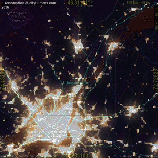
Analysis of L'Assomption night lights 2016
Square area 10x10 km:
 3.27%
3.27%90-99
6.7%80-89
5.21%70-79
2.53%60-69
3.13%50-59
3.27%40-49
3.13%30-39
6.99%20-29
20.24%10-19
36.16%0-9
9.38%Square area 50x50 km:
5.13%90-99
5.37%80-89
2.24%70-79
2.61%60-69
3.39%50-59
3.73%40-49
3.52%30-39
3.79%20-29
5.76%10-19
10.15%0-9
54.3%Clear (daylight) street map image can be seen on geolist.org.
Map coordinates:
46° 18' 39.6" North, 74° 7' 57.1" West
45° 49' 23.4" North, 73° 25' 45.8" West
45° 19' 51.7" North, 72° 43' 34.6" West
Some cities around L'Assomption sort by population:
• Terrebonne
21.8 km =13.5 mi,  230°
230°
• Repentigny
9.1 km =5.7 mi,  190°
190°
• Joliette
21.5 km =13.4 mi,  1°
1°
• Mascouche
15.5 km =9.6 mi,  238°
238°
• Varennes
15.5 km =9.6 mi,  180°
180°
• Saint-Amable
21.7 km =13.5 mi,  152°
152°
• Lavaltrie
13.2 km =8.2 mi,  59°
59°
• Charlemagne
12.5 km =7.8 mi,  199°
199°
6050263 (p: 15,906)
Sources (retrieved 2019-11-25):
» Earth at Night: Flat Maps 2012, 2016