Lavaltrie night lights from space
Night Light of Lavaltrie (Quebec) from space (Canada) Src. Average luminocity for 10x10km area is 17.7723% and for 50x50km: 15.8397%.
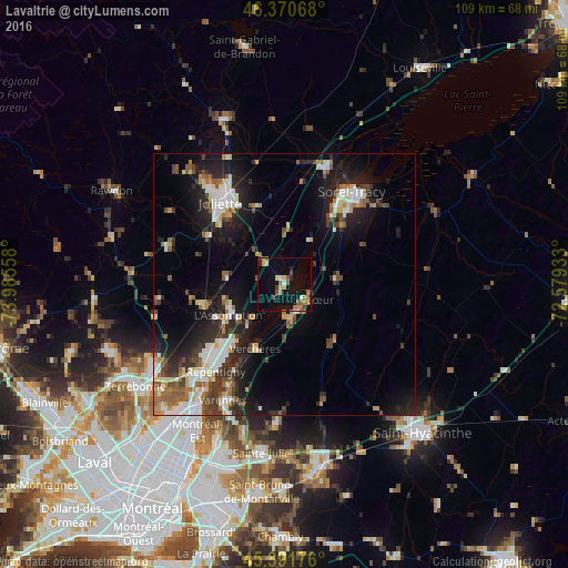
Analysis of Lavaltrie night lights 2016
Square area 10x10 km:
 0.45%
0.45%90-99
1.19%80-89
3.57%70-79
1.19%60-69
5.21%50-59
3.27%40-49
1.64%30-39
1.64%20-29
2.08%10-19
17.11%0-9
62.65%Square area 50x50 km:
2.09%90-99
3.22%80-89
1.61%70-79
1.47%60-69
1.93%50-59
2.09%40-49
2.04%30-39
2.69%20-29
4.88%10-19
10.51%0-9
67.46%Clear (daylight) street map image can be seen on geolist.org.
Map coordinates:
46° 22' 14.4" North, 73° 59' 8.1" West
45° 53' 0.2" North, 73° 16' 56.8" West
45° 23' 30.3" North, 72° 34' 45.6" West
Some cities around Lavaltrie sort by population:
• Repentigny
20.4 km =12.7 mi,  219°
219°
• Sorel-Tracy
21.9 km =13.6 mi,  36°
36°
• Joliette
18.4 km =11.4 mi,  323°
323°
• Varennes
25.1 km =15.6 mi,  207°
207°
• L'Assomption
13.2 km =8.2 mi,  239°
239°
• Saint-Amable
26 km =16.2 mi,  182°
182°
• Notre-Dame-des-Prairies
21.9 km =13.6 mi,  327°
327°
• Charlemagne
24.2 km =15 mi, 219°
6050650 (p: 8,762)
Sources (retrieved 2019-11-25):
» Earth at Night: Flat Maps 2012, 2016