Lachute night lights from space
Night Light of Lachute (Quebec) from space (Canada) Src. Average luminocity for 10x10km area is 19.3894% and for 50x50km: 6.3078%.
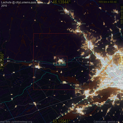
Analysis of Lachute night lights 2016
Square area 10x10 km:
 0.45%
0.45%90-99
5%80-89
1.82%70-79
0.45%60-69
2.88%50-59
2.58%40-49
3.79%30-39
5.15%20-29
2.73%10-19
18.94%0-9
56.21%Square area 50x50 km:
0.44%90-99
0.77%80-89
0.67%70-79
0.58%60-69
0.63%50-59
0.84%40-49
1.38%30-39
1.61%20-29
2.25%10-19
5.18%0-9
85.64%Clear (daylight) street map image can be seen on geolist.org.
Map coordinates:
46° 8' 22" North, 75° 2' 8.4" West
45° 39' 0.3" North, 74° 19' 57.1" West
45° 9' 23.1" North, 73° 37' 45.9" West
Some cities around Lachute sort by population:
• Saint-Jérôme
29.4 km =18.3 mi,  60°
60°
• Mirabel
19.4 km =12.1 mi,  90°
90°
• Hawkesbury
22.7 km =14.1 mi,  255°
255°
• Saint-Canut
20.6 km =12.8 mi,  69°
69°
• Saint-Sauveur
28.9 km =18 mi,  24°
24°
• Brownsburg-Chatham
7.5 km =4.7 mi,  299°
299°
• Saint-Joseph-du-Lac
29 km =18 mi,  116°
116°
• Hudson
26.4 km =16.4 mi,  147°
147°
6024829 (p: 9,562)
Sources (retrieved 2019-11-25):
» Earth at Night: Flat Maps 2012, 2016