Saint-Joseph-du-Lac night lights from space
Night Light of Saint-Joseph-du-Lac (Quebec) from space (Canada) Src. Average luminocity for 10x10km area is 26.3591% and for 50x50km: 35.6946%.
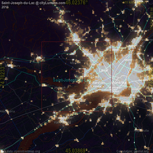
Analysis of Saint-Joseph-du-Lac night lights 2016
Square area 10x10 km:
 0.61%
0.61%90-99
2.58%80-89
4.39%70-79
3.33%60-69
2.42%50-59
5.76%40-49
5.61%30-39
8.03%20-29
16.97%10-19
11.97%0-9
38.33%Square area 50x50 km:
9.55%90-99
7.77%80-89
3.53%70-79
4.03%60-69
3.55%50-59
3.2%40-49
4.04%30-39
5.56%20-29
10.11%10-19
12.72%0-9
35.95%Clear (daylight) street map image can be seen on geolist.org.
Map coordinates:
46° 1' 25.5" North, 74° 42' 8.4" West
45° 32' 0.2" North, 73° 59' 57.1" West
45° 2' 19.3" North, 73° 17' 45.9" West
Some cities around Saint-Joseph-du-Lac sort by population:
• Dollard-Des Ormeaux
14.3 km =8.9 mi,  107°
107°
• Mirabel
14.5 km =9 mi,  333°
333°
• Vaudreuil-Dorion
15 km =9.3 mi,  189°
189°
• Kirkland
13.9 km =8.6 mi,  131°
131°
• Beaconsfield
15.2 km =9.4 mi,  136°
136°
• Deux-Montagnes
7.6 km =4.7 mi,  89°
89°
• Pointe-Calumet
4.5 km =2.8 mi, 144°
• Hudson
14.9 km =9.3 mi,  231°
231°
6138573 (p: 6,195)
Sources (retrieved 2019-11-25):
» Earth at Night: Flat Maps 2012, 2016