Saint-Canut night lights from space
Night Light of Saint-Canut (Quebec) from space (Canada) Src. Average luminocity for 10x10km area is 26.7985% and for 50x50km: 22.2374%.
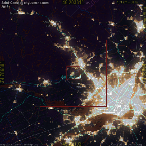
Analysis of Saint-Canut night lights 2016
Square area 10x10 km:
 2.58%
2.58%90-99
2.88%80-89
3.18%70-79
3.18%60-69
2.88%50-59
3.18%40-49
3.33%30-39
6.67%20-29
15.91%10-19
26.82%0-9
29.39%Square area 50x50 km:
3.94%90-99
4.65%80-89
2.51%70-79
2.72%60-69
2.49%50-59
2.27%40-49
3.44%30-39
3.79%20-29
6.63%10-19
10.56%0-9
57.01%Clear (daylight) street map image can be seen on geolist.org.
Map coordinates:
46° 12' 13.7" North, 74° 47' 12.8" West
45° 42' 54.1" North, 74° 5' 1.5" West
45° 13' 18.9" North, 73° 22' 50.3" West
Some cities around Saint-Canut sort by population:
• Blainville
16.5 km =10.3 mi,  108°
108°
• Mirabel
7.2 km =4.5 mi,  179°
179°
• Boisbriand
22.4 km =13.9 mi,  119°
119°
• Deux-Montagnes
24.6 km =15.3 mi,  144°
144°
• Rosemère
23.9 km =14.9 mi, 112°
• Prévost
16.9 km =10.5 mi,  0°
0°
• Lorraine
23.7 km =14.7 mi,  98°
98°
• Lachute
20.6 km =12.8 mi,  249°
249°
6137557 (p: 10,643)
Sources (retrieved 2019-11-25):
» Earth at Night: Flat Maps 2012, 2016