Paro night lights from space
Night Light of Paro from space (Bhutan) Src. Average luminocity for 10x10km area is 9.7386% and for 50x50km: 2.1004%.
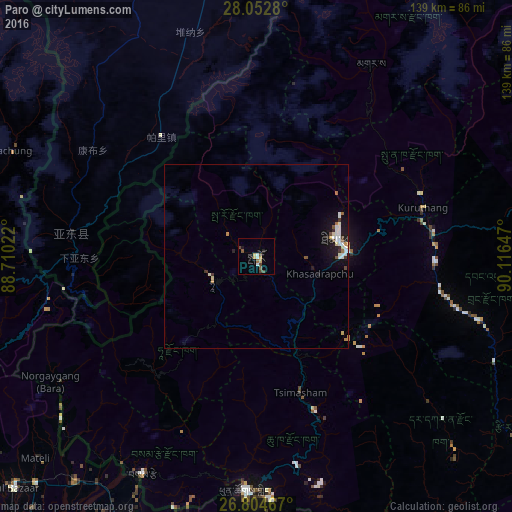
Analysis of Paro night lights 2016
Square area 10x10 km:
100  0.57%
0.57%
90-99 1.7%
80-89 1.7%
70-79 0.57%
60-69 1.52%
50-59 1.52%
40-49 3.03%
30-39 0.76%
20-29 1.33%
10-19 0.95%
0-9 86.36%
0.57%90-99
1.7%80-89
1.7%70-79
0.57%60-69
1.52%50-59
1.52%40-49
3.03%30-39
0.76%20-29
1.33%10-19
0.95%0-9
86.36%Square area 50x50 km:
100 0.46%
90-99 0.39%
80-89 0.23%
70-79 0.17%
60-69 0.2%
50-59 0.16%
40-49 0.28%
30-39 0.18%
20-29 0.22%
10-19 1.5%
0-9 96.22%
0.46%90-99
0.39%80-89
0.23%70-79
0.17%60-69
0.2%50-59
0.16%40-49
0.28%30-39
0.18%20-29
0.22%10-19
1.5%0-9
96.22%Clear (daylight) street map image can be seen on geolist.org.
Map coordinates:
28° 3' 10.1" North, 88° 42' 36.8" East
27° 25' 49.8" North, 89° 24' 48" East
26° 48' 16.8" North, 90° 6' 59.3" East
Some cities around Paro sort by population:
• Thimphu
22.9 km =14.2 mi,  80°
80°
• Punākha
49.1 km =30.5 mi,  68°
68°
• Wangdue Phodrang
48.3 km =30 mi, 82°
• Tsimasham
38.8 km =24.1 mi,  161°
161°
• Daga
60.5 km =37.6 mi,  130°
130°
• Ha
13.9 km =8.6 mi,  249°
249°
• Gasa
61 km =37.9 mi,  30°
30°
• Lungtenzampa
23.2 km =14.4 mi, 79°
1252490 (p: 2,169)
Sources (retrieved 2019-11-25):
» Earth at Night: Flat Maps 2012, 2016