Urupês night lights from space
Night Light of Urupês (São Paulo) from space (Brazil) Src. Average luminocity for 10x10km area is 6.6687% and for 50x50km: 3.1776%.
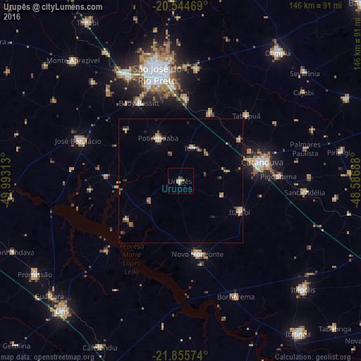
Analysis of Urupês night lights 2016
Square area 10x10 km:
 0.99%
0.99%90-99
0.6%80-89
0.79%70-79
2.98%60-69
0.2%50-59
0%40-49
0.79%30-39
1.19%20-29
0.4%10-19
0%0-9
92.06%Square area 50x50 km:
0.21%90-99
0.26%80-89
0.28%70-79
0.77%60-69
0.62%50-59
0.39%40-49
0.48%30-39
0.44%20-29
0.44%10-19
0.29%0-9
95.81%Clear (daylight) street map image can be seen on geolist.org.
Map coordinates:
20° 32' 40.9" South, 49° 59' 35.3" West
21° 12' 6" South, 49° 17' 24" West
21° 51' 20.7" South, 48° 35' 12.8" West
Some cities around Urupês sort by population:
• São José do Rio Preto
43.5 km =27 mi,  347°
347°
• Catanduva
33.6 km =20.9 mi,  77°
77°
• Novo Horizonte
30.5 km =19 mi,  166°
166°
• José Bonifácio
44.5 km =27.7 mi,  291°
291°
• Bady Bassitt
35.4 km =22 mi,  332°
332°
• Guapiaçu
45.8 km =28.5 mi,  9°
9°
• Pindorama
39.7 km =24.7 mi,  87°
87°
• Itajobi
27.6 km =17.1 mi,  117°
117°
3445675 (p: 10,745)
Sources (retrieved 2019-11-25):
» Earth at Night: Flat Maps 2012, 2016