Bady Bassitt night lights from space
Night Light of Bady Bassitt (São Paulo) from space (Brazil) Src. Average luminocity for 10x10km area is 25.6012% and for 50x50km: 17.8518%.
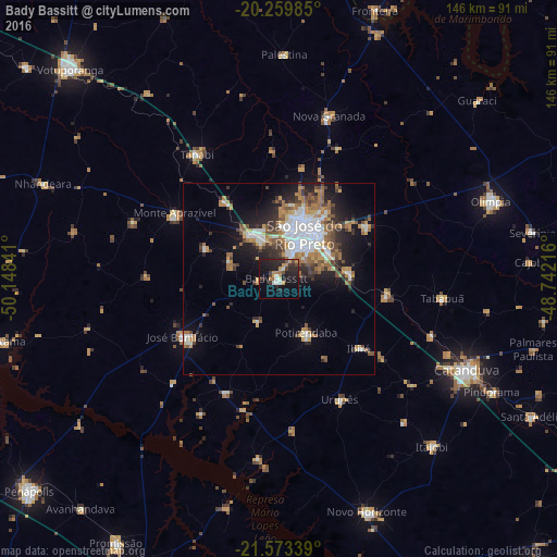
Analysis of Bady Bassitt night lights 2016
Square area 10x10 km:
 1.79%
1.79%90-99
2.98%80-89
0.79%70-79
5.75%60-69
4.56%50-59
0.79%40-49
4.56%30-39
3.57%20-29
14.68%10-19
28.37%0-9
32.14%Square area 50x50 km:
3.72%90-99
2.76%80-89
0.88%70-79
2.63%60-69
3.45%50-59
1.84%40-49
2.62%30-39
2.52%20-29
4.31%10-19
8.22%0-9
67.05%Clear (daylight) street map image can be seen on geolist.org.
Map coordinates:
20° 15' 35.5" South, 50° 8' 54.3" West
20° 55' 5" South, 49° 26' 43" West
21° 34' 24.2" South, 48° 44' 31.8" West
Some cities around Bady Bassitt sort by population:
• São José do Rio Preto
12.9 km =8 mi,  32°
32°
• Catanduva
54.8 km =34.1 mi,  116°
116°
• José Bonifácio
29.3 km =18.2 mi,  239°
239°
• Tanabi
38.7 km =24 mi,  326°
326°
• Monte Aprazível
32.3 km =20.1 mi,  300°
300°
• Nova Granada
44.8 km =27.8 mi,  17°
17°
• Guapiaçu
27.1 km =16.8 mi,  59°
59°
• Urupês
35.4 km =22 mi,  152°
152°
3471210 (p: 14,214)
Sources (retrieved 2019-11-25):
» Earth at Night: Flat Maps 2012, 2016