Guapiaçu night lights from space
Night Light of Guapiaçu (São Paulo) from space (Brazil) Src. Average luminocity for 10x10km area is 16.0114% and for 50x50km: 13.8453%.
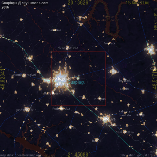
Analysis of Guapiaçu night lights 2016
Square area 10x10 km:
 1.14%
1.14%90-99
1.14%80-89
0.19%70-79
5.11%60-69
3.03%50-59
1.52%40-49
2.08%30-39
2.46%20-29
2.27%10-19
19.89%0-9
61.17%Square area 50x50 km:
3.11%90-99
2.16%80-89
0.64%70-79
2.11%60-69
2.87%50-59
1.53%40-49
2.11%30-39
1.88%20-29
3.11%10-19
5.32%0-9
75.17%Clear (daylight) street map image can be seen on geolist.org.
Map coordinates:
20° 8' 10.5" South, 49° 55' 24.3" West
20° 47' 42" South, 49° 13' 13" West
21° 27' 3.2" South, 48° 31' 1.8" West
Some cities around Guapiaçu sort by population:
• São José do Rio Preto
16.8 km =10.4 mi,  260°
260°
• Catanduva
46 km =28.6 mi,  146°
146°
• Olímpia
32.4 km =20.1 mi,  78°
78°
• Tanabi
48.4 km =30.1 mi,  292°
292°
• Nova Granada
30.6 km =19 mi,  341°
341°
• Bady Bassitt
27.1 km =16.8 mi,  239°
239°
• Severínia
43.4 km =27 mi,  92°
92°
• Urupês
45.8 km =28.5 mi,  189°
189°
3461954 (p: 14,065)
Sources (retrieved 2019-11-25):
» Earth at Night: Flat Maps 2012, 2016