Três Passos night lights from space
Night Light of Três Passos (Rio Grande do Sul) from space (Brazil) Src. Average luminocity for 10x10km area is 18.994% and for 50x50km: 2.1441%.
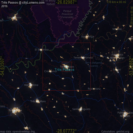
Analysis of Três Passos night lights 2016
Square area 10x10 km:
 1.98%
1.98%90-99
1.98%80-89
4.76%70-79
2.38%60-69
3.17%50-59
1.98%40-49
2.18%30-39
1.98%20-29
0.99%10-19
6.35%0-9
72.22%Square area 50x50 km:
0.16%90-99
0.19%80-89
0.44%70-79
0.21%60-69
0.58%50-59
0.26%40-49
0.31%30-39
0.31%20-29
0.16%10-19
0.38%0-9
96.99%Clear (daylight) street map image can be seen on geolist.org.
Map coordinates:
26° 49' 47.5" South, 54° 38' 6.3" West
27° 27' 20" South, 53° 55' 55" West
28° 4' 39.8" South, 53° 13' 43.8" West
Some cities around Três Passos sort by population:
• Santa Rosa
71.1 km =44.2 mi,  229°
229°
• Frederico Westphalen
54.1 km =33.6 mi,  78°
78°
• El Soberbio, AR
31.6 km =19.6 mi,  303°
303°
• Horizontina
41.6 km =25.8 mi,  242°
242°
• Giruá
75.8 km =47.1 mi,  212°
212°
• Santo Augusto
46.5 km =28.9 mi,  160°
160°
• Colonia Aurora, AR
58.5 km =36.4 mi,  267°
267°
• Alba Posse, AR
75.1 km =46.7 mi,  260°
260°
3446087 (p: 17,286)
Sources (retrieved 2019-11-25):
» Earth at Night: Flat Maps 2012, 2016