Santo Augusto night lights from space
Night Light of Santo Augusto (Rio Grande do Sul) from space (Brazil) Src. Average luminocity for 10x10km area is 11.0114% and for 50x50km: 1.1321%.
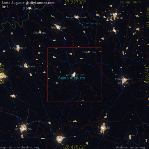
Analysis of Santo Augusto night lights 2016
Square area 10x10 km:
 2.08%
2.08%90-99
1.7%80-89
1.33%70-79
0.95%60-69
2.08%50-59
0.95%40-49
0.19%30-39
1.89%20-29
2.46%10-19
0.95%0-9
85.42%Square area 50x50 km:
0.11%90-99
0.11%80-89
0.17%70-79
0.17%60-69
0.3%50-59
0.13%40-49
0.06%30-39
0.32%20-29
0.26%10-19
0.1%0-9
98.29%Clear (daylight) street map image can be seen on geolist.org.
Map coordinates:
27° 13' 38.6" South, 54° 28' 49.3" West
27° 51' 3" South, 53° 46' 38" West
28° 28' 14.6" South, 53° 4' 26.8" West
Some cities around Santo Augusto sort by population:
• Ijuí
61.2 km =38 mi,  192°
192°
• Palmeira das Missões
45.9 km =28.5 mi,  96°
96°
• Panambi
56.1 km =34.9 mi,  151°
151°
• Frederico Westphalen
66.4 km =41.3 mi,  34°
34°
• Três de Maio
46.3 km =28.8 mi,  280°
280°
• Três Passos
46.5 km =28.9 mi,  340°
340°
• Horizontina
57.9 km =36 mi,  295°
295°
• Giruá
59.6 km =37 mi,  250°
250°
3449476 (p: 10,305)
Sources (retrieved 2019-11-25):
» Earth at Night: Flat Maps 2012, 2016