Touros night lights from space
Night Light of Touros (Rio Grande do Norte) from space (Brazil) Src. Average luminocity for 10x10km area is 8.7479% and for 50x50km: 1.5033%.
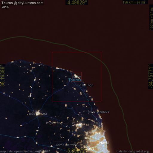
Analysis of Touros night lights 2016
Square area 10x10 km:
 0.41%
0.41%90-99
1.24%80-89
1.45%70-79
0.21%60-69
1.65%50-59
3.72%40-49
0.62%30-39
1.45%20-29
1.65%10-19
0%0-9
87.6%Square area 50x50 km:
0.02%90-99
0.13%80-89
0.16%70-79
0.18%60-69
0.13%50-59
0.52%40-49
0.25%30-39
0.56%20-29
0.54%10-19
0.16%0-9
97.35%Clear (daylight) street map image can be seen on geolist.org.
Map coordinates:
4° 29' 53.8" South, 36° 9' 50.3" West
5° 11' 56" South, 35° 27' 39" West
5° 53' 55.4" South, 34° 45' 27.8" West
Some cities around Touros sort by population:
• Natal
71.9 km =44.7 mi,  157°
157°
• Macaíba
74.3 km =46.2 mi,  170°
170°
• Ceará Mirim
48.6 km =30.2 mi,  175°
175°
• João Câmara
54.7 km =34 mi,  226°
226°
• Extremoz
58.8 km =36.5 mi, 163°
• São Miguel
31.5 km =19.6 mi, 160°
• São Gonçalo do Amarante
67.7 km =42.1 mi, 167°
• Poço Branco
52.2 km =32.4 mi,  205°
205°
3386213 (p: 7,662)
Sources (retrieved 2019-11-25):
» Earth at Night: Flat Maps 2012, 2016