Poço Branco night lights from space
Night Light of Poço Branco (Rio Grande do Norte) from space (Brazil) Src. Average luminocity for 10x10km area is 7.0475% and for 50x50km: 3.9067%.
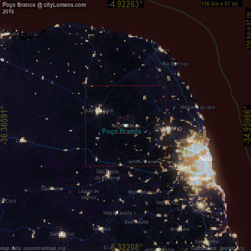
Analysis of Poço Branco night lights 2016
Square area 10x10 km:
 0%
0%90-99
1.45%80-89
1.86%70-79
0%60-69
1.03%50-59
1.65%40-49
1.03%30-39
0.83%20-29
1.03%10-19
1.03%0-9
90.08%Square area 50x50 km:
0.05%90-99
0.4%80-89
0.53%70-79
0.2%60-69
0.63%50-59
1.17%40-49
0.74%30-39
0.93%20-29
0.74%10-19
1.77%0-9
92.84%Clear (daylight) street map image can be seen on geolist.org.
Map coordinates:
4° 55' 21.5" South, 36° 21' 57.3" West
5° 37' 22" South, 35° 39' 46" West
6° 19' 19.5" South, 34° 57' 34.8" West
Some cities around Poço Branco sort by population:
• Macaíba
43.1 km =26.8 mi,  127°
127°
• Ceará Mirim
26.3 km =16.3 mi,  92°
92°
• João Câmara
19.8 km =12.3 mi,  298°
298°
• Extremoz
40.4 km =25.1 mi,  103°
103°
• São Miguel
37.1 km =23.1 mi,  62°
62°
• São Gonçalo do Amarante
41.5 km =25.8 mi,  117°
117°
• São Paulo do Potengi
32.2 km =20 mi,  200°
200°
• Touros
52.2 km =32.4 mi,  25°
25°
3391744 (p: 7,112)
Sources (retrieved 2019-11-25):
» Earth at Night: Flat Maps 2012, 2016