Extremoz night lights from space
Night Light of Extremoz (Rio Grande do Norte) from space (Brazil) Src. Average luminocity for 10x10km area is 60.7562% and for 50x50km: 26.1767%.
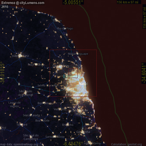
Analysis of Extremoz night lights 2016
Square area 10x10 km:
 6.82%
6.82%90-99
16.74%80-89
11.57%70-79
4.96%60-69
12.19%50-59
11.57%40-49
9.92%30-39
7.02%20-29
9.92%10-19
9.09%0-9
0.21%Square area 50x50 km:
4.24%90-99
6.25%80-89
4.16%70-79
2.64%60-69
4%50-59
3.45%40-49
3.17%30-39
2.79%20-29
4.34%10-19
11.3%0-9
53.66%Clear (daylight) street map image can be seen on geolist.org.
Map coordinates:
5° 0' 19.8" South, 36° 0' 37.3" West
5° 42' 20" South, 35° 18' 26" West
6° 24' 17.1" South, 34° 36' 14.8" West
Some cities around Extremoz sort by population:
• Natal
14.7 km =9.1 mi,  132°
132°
• Parnamirim
23.9 km =14.9 mi,  168°
168°
• Macaíba
17.8 km =11.1 mi,  196°
196°
• Ceará Mirim
15.3 km =9.5 mi,  301°
301°
• São José de Mipibu
41.8 km =26 mi, 169°
• São Miguel
27.4 km =17 mi,  346°
346°
• São Gonçalo do Amarante
10.1 km =6.3 mi,  194°
194°
• Poço Branco
40.4 km =25.1 mi,  283°
283°
3400567 (p: 17,991)
Sources (retrieved 2019-11-25):
» Earth at Night: Flat Maps 2012, 2016