São Sebastião night lights from space
Night Light of São Sebastião (Alagoas) from space (Brazil) Src. Average luminocity for 10x10km area is 17.8533% and for 50x50km: 15.1852%.
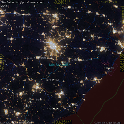
Analysis of São Sebastião night lights 2016
Square area 10x10 km:
 1.45%
1.45%90-99
2.69%80-89
0%70-79
4.13%60-69
0%50-59
3.51%40-49
3.1%30-39
1.86%20-29
1.45%10-19
13.02%0-9
68.8%Square area 50x50 km:
1.3%90-99
3.1%80-89
1.14%70-79
1.4%60-69
2.6%50-59
3.62%40-49
2.36%30-39
2.82%20-29
4.23%10-19
6.9%0-9
70.53%Clear (daylight) street map image can be seen on geolist.org.
Map coordinates:
9° 14' 25.1" South, 37° 15' 26.3" West
9° 56' 1" South, 36° 33' 15" West
10° 37' 31.6" South, 35° 51' 3.8" West
Some cities around São Sebastião sort by population:
• Arapiraca
23.3 km =14.5 mi,  329°
329°
• Campo Alegre
27.9 km =17.3 mi,  52°
52°
• Cajueiro
26.7 km =16.6 mi,  25°
25°
• Lagoa da Canoa
23.2 km =14.4 mi,  299°
299°
• Girau do Ponciano
30.6 km =19 mi,  280°
280°
• Anadia
39 km =24.2 mi,  44°
44°
• Junqueiro
8.6 km =5.3 mi,  83°
83°
• Taquarana
32.7 km =20.3 mi,  11°
11°
3388112 (p: 9,551)
Sources (retrieved 2019-11-25):
» Earth at Night: Flat Maps 2012, 2016