Igaci night lights from space
Night Light of Igaci (Alagoas) from space (Brazil) Src. Average luminocity for 10x10km area is 27.1797% and for 50x50km: 17.7368%.
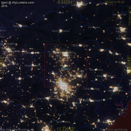
Analysis of Igaci night lights 2016
Square area 10x10 km:
 1.52%
1.52%90-99
1.95%80-89
0.87%70-79
2.6%60-69
2.81%50-59
7.14%40-49
10.17%30-39
4.11%20-29
8.66%10-19
48.27%0-9
11.9%Square area 50x50 km:
1.1%90-99
2.35%80-89
1.07%70-79
1.79%60-69
2.18%50-59
4.18%40-49
4.48%30-39
4.01%20-29
6%10-19
16.42%0-9
56.42%Clear (daylight) street map image can be seen on geolist.org.
Map coordinates:
8° 50' 34.2" South, 37° 20' 12.3" West
9° 32' 13" South, 36° 38' 1" West
10° 13' 46.7" South, 35° 55' 49.8" West
Some cities around Igaci sort by population:
• Arapiraca
24.2 km =15 mi,  187°
187°
• Cajueiro
28.4 km =17.6 mi,  134°
134°
• Lagoa da Canoa
34.5 km =21.4 mi,  199°
199°
• Maribondo
36.3 km =22.6 mi,  97°
97°
• Anadia
39.7 km =24.7 mi,  114°
114°
• Major Isidoro
38.5 km =23.9 mi,  270°
270°
• Quebrangulo
30.1 km =18.7 mi,  36°
36°
• Taquarana
19.2 km =11.9 mi, 128°
3398355 (p: 6,480)
Sources (retrieved 2019-11-25):
» Earth at Night: Flat Maps 2012, 2016