Soure night lights from space
Night Light of Soure (Pará) from space (Brazil) Src. Average luminocity for 10x10km area is 19.697% and for 50x50km: 1.282%.
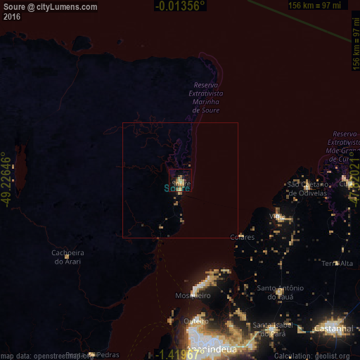
Analysis of Soure night lights 2016
Square area 10x10 km:
 0%
0%90-99
0.65%80-89
5.19%70-79
5.84%60-69
2.16%50-59
3.68%40-49
2.81%30-39
2.16%20-29
3.03%10-19
8.01%0-9
66.45%Square area 50x50 km:
0%90-99
0.03%80-89
0.26%70-79
0.28%60-69
0.1%50-59
0.36%40-49
0.33%30-39
0.12%20-29
0.24%10-19
0.37%0-9
97.91%Clear (daylight) street map image can be seen on geolist.org.
Map coordinates:
0° 0' 48.8" South, 49° 13' 35.3" West
0° 43' 0" South, 48° 31' 24" West
1° 25' 10.8" South, 47° 49' 12.8" West
Some cities around Soure sort by population:
• Belém
82.2 km =51.1 mi,  178°
178°
• Ananindeua
74.1 km =46 mi,  166°
166°
• Benevides
78.1 km =48.5 mi,  156°
156°
• Barcarena
88.5 km =55 mi,  187°
187°
• Vigia
45.3 km =28.1 mi,  110°
110°
• Curuçá
75.1 km =46.7 mi,  91°
91°
• Santo Antônio do Tauá
65.3 km =40.6 mi,  137°
137°
• São Caetano de Odivelas
56.1 km =34.9 mi, 93°
3387204 (p: 18,212)
Sources (retrieved 2019-11-25):
» Earth at Night: Flat Maps 2012, 2016