Curuçá night lights from space
Night Light of Curuçá (Pará) from space (Brazil) Src. Average luminocity for 10x10km area is 20.0931% and for 50x50km: 3.4875%.
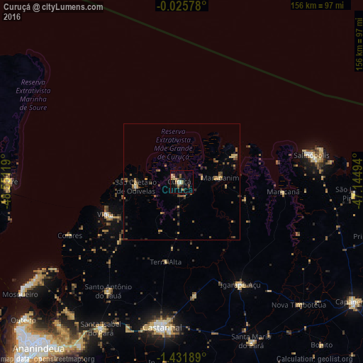
Analysis of Curuçá night lights 2016
Square area 10x10 km:
 0.22%
0.22%90-99
3.25%80-89
5.19%70-79
1.73%60-69
1.52%50-59
5.84%40-49
2.16%30-39
1.08%20-29
4.11%10-19
8.01%0-9
66.88%Square area 50x50 km:
0.03%90-99
0.17%80-89
0.61%70-79
0.56%60-69
0.42%50-59
1%40-49
0.55%30-39
0.57%20-29
0.7%10-19
0.75%0-9
94.63%Clear (daylight) street map image can be seen on geolist.org.
Map coordinates:
0° 1' 32.8" South, 48° 33' 4.3" West
0° 43' 44" South, 47° 50' 53" West
1° 25' 54.8" South, 47° 8' 41.8" West
Some cities around Curuçá sort by population:
• Castanhal
63.4 km =39.4 mi,  187°
187°
• Salinópolis
56.2 km =34.9 mi,  76°
76°
• Vigia
35.7 km =22.2 mi,  246°
246°
• Igarapé Açu
51.2 km =31.8 mi,  150°
150°
• Maracanã
44 km =27.3 mi,  95°
95°
• Marapanim
16.5 km =10.3 mi,  85°
85°
• Santo Antônio do Tauá
56.5 km =35.1 mi,  213°
213°
• São Caetano de Odivelas
19.3 km =12 mi,  262°
262°
3401188 (p: 10,843)
Sources (retrieved 2019-11-25):
» Earth at Night: Flat Maps 2012, 2016