São Caetano de Odivelas night lights from space
Night Light of São Caetano de Odivelas (Pará) from space (Brazil) Src. Average luminocity for 10x10km area is 13.2273% and for 50x50km: 4.1638%.
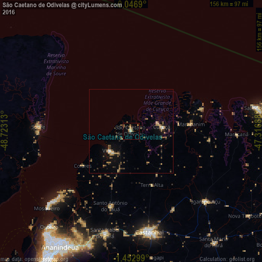
Analysis of São Caetano de Odivelas night lights 2016
Square area 10x10 km:
 0.65%
0.65%90-99
1.08%80-89
2.38%70-79
3.25%60-69
1.3%50-59
2.16%40-49
1.08%30-39
3.03%20-29
2.16%10-19
1.08%0-9
81.82%Square area 50x50 km:
0.1%90-99
0.29%80-89
0.54%70-79
0.58%60-69
0.62%50-59
0.85%40-49
0.93%30-39
0.73%20-29
0.7%10-19
1.96%0-9
92.7%Clear (daylight) street map image can be seen on geolist.org.
Map coordinates:
0° 2' 48.8" South, 48° 43' 23.3" West
0° 45' 0" South, 48° 1' 12" West
1° 27' 10.8" South, 47° 19' 0.8" West
Some cities around São Caetano de Odivelas sort by population:
• Castanhal
61.4 km =38.2 mi,  170°
170°
• Vigia
18.1 km =11.2 mi,  228°
228°
• Igarapé Açu
61.3 km =38.1 mi,  133°
133°
• Soure
56.1 km =34.9 mi,  273°
273°
• Maracanã
63 km =39.1 mi,  91°
91°
• Curuçá
19.3 km =12 mi,  82°
82°
• Marapanim
35.8 km =22.2 mi, 84°
• Santo Antônio do Tauá
46.3 km =28.8 mi,  195°
195°
3388926 (p: 8,862)
Sources (retrieved 2019-11-25):
» Earth at Night: Flat Maps 2012, 2016