Sombrio night lights from space
Night Light of Sombrio (Santa Catarina) from space (Brazil) Src. Average luminocity for 10x10km area is 27.1052% and for 50x50km: 7.4777%.
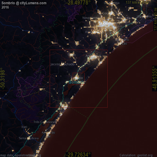
Analysis of Sombrio night lights 2016
Square area 10x10 km:
 2.38%
2.38%90-99
2.38%80-89
2.38%70-79
4.37%60-69
4.76%50-59
8.33%40-49
4.37%30-39
3.37%20-29
1.79%10-19
35.52%0-9
30.36%Square area 50x50 km:
0.47%90-99
0.54%80-89
1.33%70-79
0.76%60-69
1.11%50-59
1.39%40-49
1.12%30-39
1.36%20-29
1.25%10-19
6.63%0-9
84.02%Clear (daylight) street map image can be seen on geolist.org.
Map coordinates:
28° 29' 52" South, 50° 19' 11.3" West
29° 6' 50" South, 49° 37' 0" West
29° 43' 34.8" South, 48° 54' 48.8" West
Some cities around Sombrio sort by population:
• Criciúma
54.2 km =33.7 mi,  26°
26°
• Içara
54.2 km =33.7 mi, 34°
• Araranguá
23.1 km =14.4 mi, 30°
• Torres
26.8 km =16.7 mi,  203°
203°
• Forquilhinha
43.1 km =26.8 mi,  19°
19°
• Morro da Fumaça
65 km =40.4 mi,  37°
37°
• Cocal
63.4 km =39.4 mi, 26°
• Siderópolis
60.4 km =37.5 mi, 18°
3447409 (p: 14,864)
Sources (retrieved 2019-11-25):
» Earth at Night: Flat Maps 2012, 2016