Siderópolis night lights from space
Night Light of Siderópolis (Santa Catarina) from space (Brazil) Src. Average luminocity for 10x10km area is 22.3504% and for 50x50km: 17.2304%.
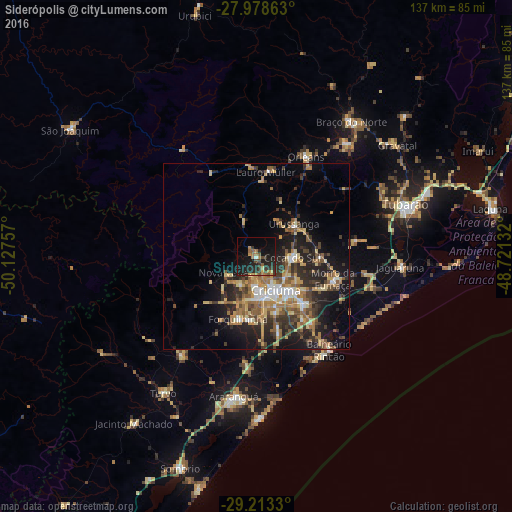
Analysis of Siderópolis night lights 2016
Square area 10x10 km:
 0%
0%90-99
0.76%80-89
1.89%70-79
3.41%60-69
5.3%50-59
3.41%40-49
3.6%30-39
5.87%20-29
14.2%10-19
24.81%0-9
36.74%Square area 50x50 km:
1.28%90-99
1.78%80-89
2.84%70-79
2.54%60-69
3.08%50-59
3.32%40-49
2.34%30-39
3.78%20-29
5.76%10-19
10.42%0-9
62.86%Clear (daylight) street map image can be seen on geolist.org.
Map coordinates:
27° 58' 43.1" South, 50° 7' 39.3" West
28° 35' 52" South, 49° 25' 28" West
29° 12' 47.9" South, 48° 43' 16.8" West
Some cities around Siderópolis sort by population:
• Criciúma
10.3 km =6.4 mi,  148°
148°
• Içara
17.7 km =11 mi,  136°
136°
• Forquilhinha
17.3 km =10.7 mi,  195°
195°
• Orleans
29.6 km =18.4 mi,  26°
26°
• Morro da Fumaça
21.7 km =13.5 mi,  105°
105°
• Cocal
9.5 km =5.9 mi,  93°
93°
• Urussanga
13.5 km =8.4 mi,  48°
48°
• Lauro Muller
23 km =14.3 mi,  6°
6°
3447598 (p: 8,536)
Sources (retrieved 2019-11-25):
» Earth at Night: Flat Maps 2012, 2016