Cocal night lights from space
Night Light of Cocal (Santa Catarina) from space (Brazil) Src. Average luminocity for 10x10km area is 36.9527% and for 50x50km: 19.3029%.
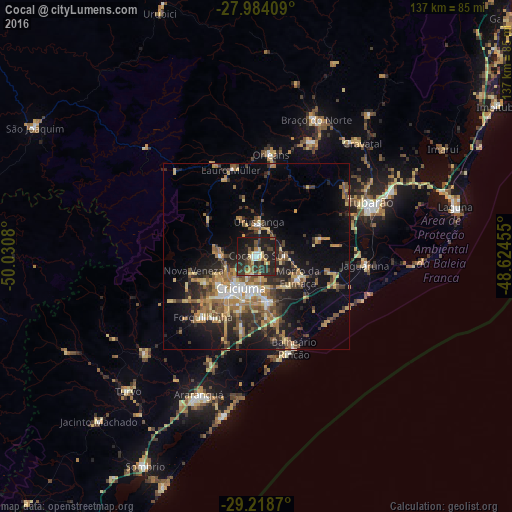
Analysis of Cocal night lights 2016
Square area 10x10 km:
 1.89%
1.89%90-99
3.41%80-89
6.82%70-79
4.92%60-69
2.65%50-59
5.68%40-49
5.87%30-39
13.26%20-29
26.33%10-19
28.22%0-9
0.95%Square area 50x50 km:
1.28%90-99
1.81%80-89
3.11%70-79
2.98%60-69
3.4%50-59
3.79%40-49
2.61%30-39
4.11%20-29
6.02%10-19
11.92%0-9
58.95%Clear (daylight) street map image can be seen on geolist.org.
Map coordinates:
27° 59' 2.7" South, 50° 1' 50.9" West
28° 36' 11.6" South, 49° 19' 39.6" West
29° 13' 7.3" South, 48° 37' 28.4" West
Some cities around Cocal sort by population:
• Criciúma
9.2 km =5.7 mi,  206°
206°
• Içara
12.5 km =7.8 mi,  167°
167°
• Forquilhinha
21.4 km =13.3 mi,  221°
221°
• Orleans
27.4 km =17 mi,  7°
7°
• Morro da Fumaça
12.6 km =7.8 mi,  114°
114°
• Urussanga
9.5 km =5.9 mi,  4°
4°
• Lauro Muller
24.3 km =15.1 mi,  343°
343°
• Siderópolis
9.5 km =5.9 mi,  273°
273°
3466005 (p: 13,303)
Sources (retrieved 2019-11-25):
» Earth at Night: Flat Maps 2012, 2016