Assaí night lights from space
Night Light of Assaí (Paraná) from space (Brazil) Src. Average luminocity for 10x10km area is 10.1989% and for 50x50km: 4.7634%.
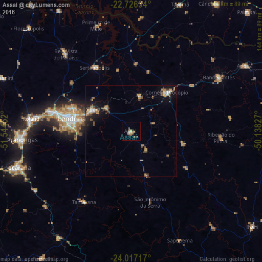
Analysis of Assaí night lights 2016
Square area 10x10 km:
 0%
0%90-99
2.08%80-89
0.57%70-79
0.95%60-69
5.11%50-59
1.7%40-49
0.19%30-39
0%20-29
3.03%10-19
0%0-9
86.36%Square area 50x50 km:
0.24%90-99
0.6%80-89
0.42%70-79
0.99%60-69
0.83%50-59
0.74%40-49
0.55%30-39
0.69%20-29
1.08%10-19
3.42%0-9
90.43%Clear (daylight) street map image can be seen on geolist.org.
Map coordinates:
22° 43' 34.8" South, 51° 32' 40.3" West
23° 22' 24" South, 50° 50' 29" West
24° 1' 1.8" South, 50° 8' 17.8" West
Some cities around Assaí sort by population:
• Londrina
33.6 km =20.9 mi,  282°
282°
• Cambé
45.9 km =28.5 mi, 283°
• Rolândia
54.3 km =33.7 mi, 277°
• Cornélio Procópio
29.2 km =18.1 mi,  42°
42°
• Ibiporã
24.1 km =15 mi,  298°
298°
• Bela Vista do Paraíso
55 km =34.2 mi,  319°
319°
• Sertanópolis
40.3 km =25 mi,  330°
330°
• Jataizinho
19.4 km =12.1 mi,  313°
313°
3471377 (p: 12,545)
Sources (retrieved 2019-11-25):
» Earth at Night: Flat Maps 2012, 2016