Bela Vista do Paraíso night lights from space
Night Light of Bela Vista do Paraíso (Paraná) from space (Brazil) Src. Average luminocity for 10x10km area is 11.881% and for 50x50km: 2.7177%.
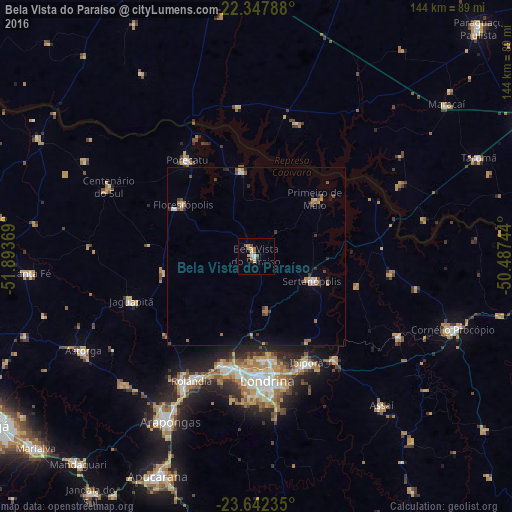
Analysis of Bela Vista do Paraíso night lights 2016
Square area 10x10 km:
 1.79%
1.79%90-99
0.6%80-89
1.19%70-79
3.57%60-69
2.38%50-59
1.79%40-49
0.6%30-39
1.19%20-29
0.4%10-19
0.6%0-9
85.91%Square area 50x50 km:
0.2%90-99
0.23%80-89
0.11%70-79
0.53%60-69
0.61%50-59
0.38%40-49
0.48%30-39
0.34%20-29
0.43%10-19
0.69%0-9
96%Clear (daylight) street map image can be seen on geolist.org.
Map coordinates:
22° 20' 52.4" South, 51° 53' 37.3" West
22° 59' 48" South, 51° 11' 26" West
23° 38' 32.5" South, 50° 29' 14.8" West
Some cities around Bela Vista do Paraíso sort by population:
• Londrina
35 km =21.7 mi,  175°
175°
• Cambé
32.3 km =20.1 mi,  196°
196°
• Rolândia
39.3 km =24.4 mi,  207°
207°
• Ibiporã
33.6 km =20.9 mi,  154°
154°
• Sertanópolis
17.2 km =10.7 mi,  113°
113°
• Florestópolis
25 km =15.5 mi,  306°
306°
• Porecatu
33 km =20.5 mi,  324°
324°
• Jataizinho
35.8 km =22.2 mi,  143°
143°
3470162 (p: 14,332)
Sources (retrieved 2019-11-25):
» Earth at Night: Flat Maps 2012, 2016