São Bento night lights from space
Night Light of São Bento (Maranhão) from space (Brazil) Src. Average luminocity for 10x10km area is 10.619% and for 50x50km: 1.7651%.
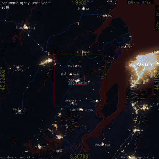
Analysis of São Bento night lights 2016
Square area 10x10 km:
 0.43%
0.43%90-99
2.16%80-89
1.73%70-79
1.08%60-69
1.95%50-59
2.16%40-49
0.87%30-39
2.16%20-29
0.43%10-19
0%0-9
87.01%Square area 50x50 km:
0.02%90-99
0.14%80-89
0.36%70-79
0.15%60-69
0.33%50-59
0.45%40-49
0.27%30-39
0.38%20-29
0.35%10-19
0.32%0-9
97.24%Clear (daylight) street map image can be seen on geolist.org.
Map coordinates:
1° 59' 35.9" South, 45° 31' 28.3" West
2° 41' 45" South, 44° 49' 17" West
3° 23' 52.7" South, 44° 7' 5.8" West
Some cities around São Bento sort by population:
• São Luís
60.5 km =37.6 mi,  72°
72°
• Pinheiro
34.9 km =21.7 mi,  303°
303°
• Viana
61.7 km =38.3 mi,  199°
199°
• Santa Helena
74.1 km =46 mi,  314°
314°
• Matinha
50.8 km =31.6 mi,  207°
207°
• Bequimão
27.8 km =17.3 mi,  8°
8°
• Alcântara
55.4 km =34.4 mi,  54°
54°
• Anajatuba
67.1 km =41.7 mi,  160°
160°
3389006 (p: 17,245)
Sources (retrieved 2019-11-25):
» Earth at Night: Flat Maps 2012, 2016