Matinha night lights from space
Night Light of Matinha (Maranhão) from space (Brazil) Src. Average luminocity for 10x10km area is 10.974% and for 50x50km: 2.627%.
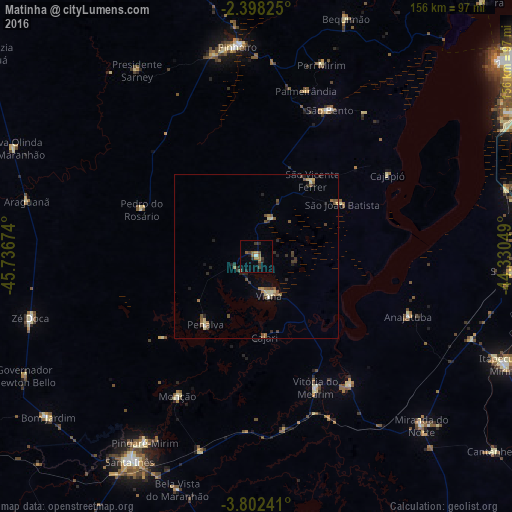
Analysis of Matinha night lights 2016
Square area 10x10 km:
 0%
0%90-99
0.87%80-89
0%70-79
1.52%60-69
3.25%50-59
3.03%40-49
1.73%30-39
3.68%20-29
3.03%10-19
1.08%0-9
81.82%Square area 50x50 km:
0.03%90-99
0.2%80-89
0.4%70-79
0.14%60-69
0.58%50-59
0.64%40-49
0.6%30-39
0.52%20-29
0.74%10-19
0.42%0-9
95.73%Clear (daylight) street map image can be seen on geolist.org.
Map coordinates:
2° 23' 53.7" South, 45° 44' 12.3" West
3° 6' 2" South, 45° 2' 1" West
3° 48' 8.7" South, 44° 19' 49.8" West
Some cities around Matinha sort by population:
• Pinheiro
64.6 km =40.1 mi,  355°
355°
• Viana
13.7 km =8.5 mi,  165°
165°
• São Bento
50.8 km =31.6 mi,  27°
27°
• Penalva
26.6 km =16.5 mi,  215°
215°
• Arari
48.3 km =30 mi,  144°
144°
• Vitória do Mearim
44.1 km =27.4 mi,  155°
155°
• Monção
49.7 km =30.9 mi,  209°
209°
• Anajatuba
49.4 km =30.7 mi,  111°
111°
3395122 (p: 6,851)
Sources (retrieved 2019-11-25):
» Earth at Night: Flat Maps 2012, 2016