Alcântara night lights from space
Night Light of Alcântara (Maranhão) from space (Brazil) Src. Average luminocity for 10x10km area is 7.2251% and for 50x50km: 13.6968%.
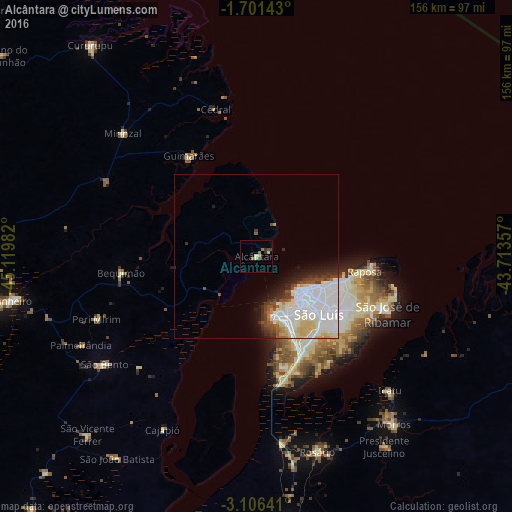
Analysis of Alcântara night lights 2016
Square area 10x10 km:
 0%
0%90-99
0%80-89
3.25%70-79
0.22%60-69
0.87%50-59
1.95%40-49
1.52%30-39
2.38%20-29
0.22%10-19
0.43%0-9
89.18%Square area 50x50 km:
5.25%90-99
3.5%80-89
2.35%70-79
0.46%60-69
0.41%50-59
0.79%40-49
1.2%30-39
1.23%20-29
1.7%10-19
2.54%0-9
80.57%Clear (daylight) street map image can be seen on geolist.org.
Map coordinates:
1° 42' 5.1" South, 45° 7' 11.4" West
2° 24' 14.8" South, 44° 25' 0.1" West
3° 6' 23.1" South, 43° 42' 48.9" West
Some cities around Alcântara sort by population:
• São Luís
18.8 km =11.7 mi,  137°
137°
• Pinheiro
75.1 km =46.7 mi,  260°
260°
• São José de Ribamar
43.9 km =27.3 mi,  113°
113°
• Cururupu
81.3 km =50.5 mi,  321°
321°
• São Bento
55.4 km =34.4 mi,  234°
234°
• Santa Helena
100 km =62.1 mi,  281°
281°
• Bequimão
40.9 km =25.4 mi, 263°
• Anajatuba
98.3 km =61.1 mi,  193°
193°
3408073 (p: 5,655)
Sources (retrieved 2019-11-25):
» Earth at Night: Flat Maps 2012, 2016