São João Nepomuceno night lights from space
Night Light of São João Nepomuceno (Minas Gerais) from space (Brazil) Src. Average luminocity for 10x10km area is 10.2197% and for 50x50km: 2.1664%.
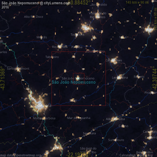

Analysis of São João Nepomuceno night lights 2016
Square area 10x10 km:
 1.33%
1.33%90-99
0.95%80-89
2.27%70-79
3.03%60-69
0%50-59
0.76%40-49
0.19%30-39
2.08%20-29
0.76%10-19
1.52%0-9
87.12%Square area 50x50 km:
0.14%90-99
0.09%80-89
0.2%70-79
0.8%60-69
0.45%50-59
0.26%40-49
0.25%30-39
0.29%20-29
0.35%10-19
0.29%0-9
96.89%Clear (daylight) street map image can be seen on geolist.org.
Map coordinates:
20° 53' 4.3" South, 43° 42' 49.3" West
21° 32' 24" South, 43° 0' 38" West
22° 11' 33.1" South, 42° 18' 26.8" West
Some cities around São João Nepomuceno sort by population:
• Cataguases
36.6 km =22.7 mi,  62°
62°
• Leopoldina
38 km =23.6 mi,  88°
88°
• Rio Pomba
34.3 km =21.3 mi,  329°
329°
• Tocantins
40.6 km =25.2 mi,  358°
358°
• Bicas
21.2 km =13.2 mi,  193°
193°
• Astolfo Dutra
29.3 km =18.2 mi,  31°
31°
• Mar de Espanha
36.4 km =22.6 mi,  179°
179°
• Rio Novo
13.8 km =8.6 mi,  300°
300°
3448846 (p: 23,154)
Sources (retrieved 2019-11-25):
» Earth at Night: Flat Maps 2012, 2016