Santa Maria de Jetibá night lights from space
Night Light of Santa Maria de Jetibá (Espírito Santo) from space (Brazil) Src. Average luminocity for 10x10km area is 11.5635% and for 50x50km: 2.2639%.
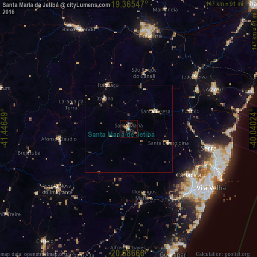
Analysis of Santa Maria de Jetibá night lights 2016
Square area 10x10 km:
 1.19%
1.19%90-99
1.19%80-89
0.79%70-79
2.18%60-69
1.39%50-59
3.57%40-49
2.38%30-39
0.79%20-29
1.59%10-19
0.79%0-9
84.13%Square area 50x50 km:
0.1%90-99
0.23%80-89
0.3%70-79
0.36%60-69
0.26%50-59
0.6%40-49
0.53%30-39
0.27%20-29
0.31%10-19
0.24%0-9
96.79%Clear (daylight) street map image can be seen on geolist.org.
Map coordinates:
19° 21' 55.7" South, 41° 26' 47.4" West
20° 1' 38.8" South, 40° 44' 36.1" West
20° 41' 12" South, 40° 2' 24.9" West
Some cities around Santa Maria de Jetibá sort by population:
• Serra
46.9 km =29.1 mi,  103°
103°
• Afonso Cláudio
40.1 km =24.9 mi,  262°
262°
• Fundão
36.9 km =22.9 mi,  73°
73°
• Ibiraçu
44.7 km =27.8 mi,  60°
60°
• Itaguaçu
27.7 km =17.2 mi,  334°
334°
• Domingos Martins
38.4 km =23.9 mi,  166°
166°
• Jetibá
6.5 km =4 mi,  83°
83°
• Marechal Floriano
43.3 km =26.9 mi, 171°
6318278 (p: 13,090)
Sources (retrieved 2019-11-25):
» Earth at Night: Flat Maps 2012, 2016