Domingos Martins night lights from space
Night Light of Domingos Martins (Espírito Santo) from space (Brazil) Src. Average luminocity for 10x10km area is 11.303% and for 50x50km: 6.2854%.
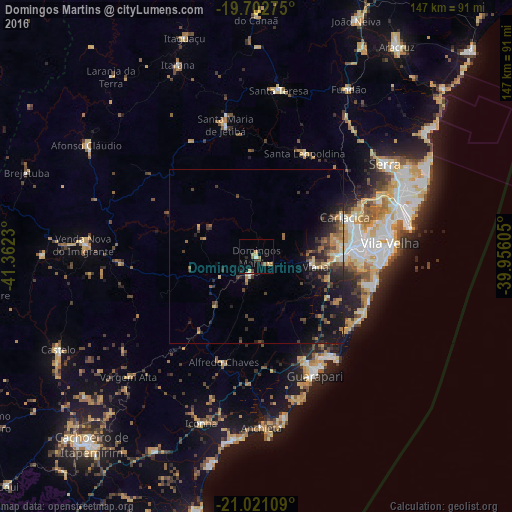
Analysis of Domingos Martins night lights 2016
Square area 10x10 km:
 0.38%
0.38%90-99
0.76%80-89
3.41%70-79
1.14%60-69
2.27%50-59
0.76%40-49
2.27%30-39
0.76%20-29
1.52%10-19
2.08%0-9
84.66%Square area 50x50 km:
0.34%90-99
0.42%80-89
0.77%70-79
1.09%60-69
0.81%50-59
0.84%40-49
1.71%30-39
1.36%20-29
2.29%10-19
4.92%0-9
85.45%Clear (daylight) street map image can be seen on geolist.org.
Map coordinates:
19° 42' 9.9" South, 41° 21' 44.3" West
20° 21' 48" South, 40° 39' 33" West
21° 1' 15.9" South, 39° 57' 21.8" West
Some cities around Domingos Martins sort by population:
• Vila Velha
38.4 km =23.9 mi,  84°
84°
• Vitória
33.9 km =21.1 mi, 81°
• Guarapari
38 km =23.6 mi,  154°
154°
• Viana
17.3 km =10.7 mi,  99°
99°
• Santa Maria de Jetibá
38.4 km =23.9 mi,  346°
346°
• Alfredo Chaves
31.6 km =19.6 mi,  197°
197°
• Jetibá
38.2 km =23.7 mi,  356°
356°
• Marechal Floriano
6 km =3.7 mi, 204°
3464556 (p: 6,061)
Sources (retrieved 2019-11-25):
» Earth at Night: Flat Maps 2012, 2016