Marechal Floriano night lights from space
Night Light of Marechal Floriano (Espírito Santo) from space (Brazil) Src. Average luminocity for 10x10km area is 12.0436% and for 50x50km: 5.906%.
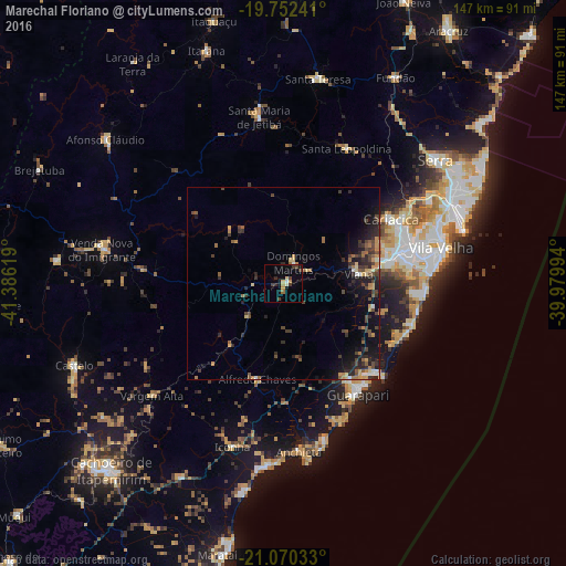
Analysis of Marechal Floriano night lights 2016
Square area 10x10 km:
 0.76%
0.76%90-99
1.14%80-89
1.52%70-79
1.89%60-69
1.89%50-59
0.38%40-49
3.6%30-39
1.89%20-29
1.89%10-19
3.98%0-9
81.06%Square area 50x50 km:
0.28%90-99
0.34%80-89
0.61%70-79
1.09%60-69
0.67%50-59
0.96%40-49
1.71%30-39
1.25%20-29
2.42%10-19
3.9%0-9
86.77%Clear (daylight) street map image can be seen on geolist.org.
Map coordinates:
19° 45' 8.7" South, 41° 23' 10.3" West
20° 24' 46" South, 40° 40' 59" West
21° 4' 13.2" South, 39° 58' 47.8" West
Some cities around Marechal Floriano sort by population:
• Vila Velha
41.7 km =25.9 mi,  77°
77°
• Vitória
37.5 km =23.3 mi,  73°
73°
• Guarapari
34.4 km =21.4 mi,  146°
146°
• Viana
19.6 km =12.2 mi, 82°
• Santa Maria de Jetibá
43.3 km =26.9 mi,  351°
351°
• Alfredo Chaves
25.7 km =16 mi,  195°
195°
• Domingos Martins
6 km =3.7 mi,  24°
24°
• Jetibá
43.6 km =27.1 mi,  0°
0°
3457770 (p: 5,869)
Sources (retrieved 2019-11-25):
» Earth at Night: Flat Maps 2012, 2016