Rubiataba night lights from space
Night Light of Rubiataba (Goiás) from space (Brazil) Src. Average luminocity for 10x10km area is 11.4401% and for 50x50km: 1.7906%.
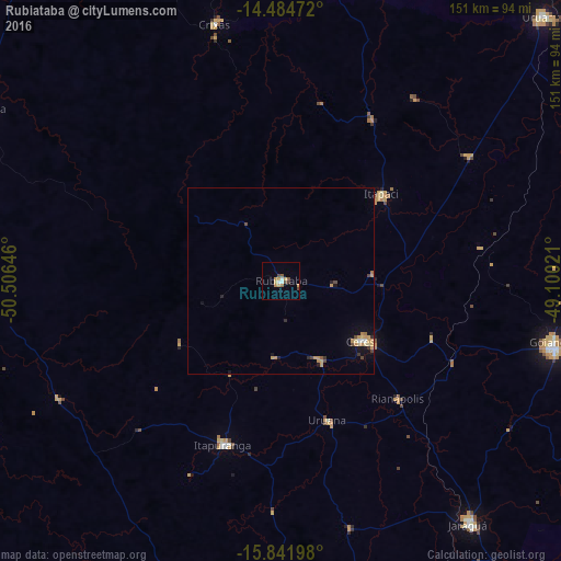
Analysis of Rubiataba night lights 2016
Square area 10x10 km:
 1.65%
1.65%90-99
0.83%80-89
1.24%70-79
3.72%60-69
0.83%50-59
1.86%40-49
2.27%30-39
0.83%20-29
0%10-19
0%0-9
86.78%Square area 50x50 km:
0.11%90-99
0.09%80-89
0.24%70-79
0.73%60-69
0.17%50-59
0.12%40-49
0.36%30-39
0.17%20-29
0.18%10-19
0.62%0-9
97.21%Clear (daylight) street map image can be seen on geolist.org.
Map coordinates:
14° 29' 5" South, 50° 30' 23.3" West
15° 9' 52" South, 49° 48' 12" West
15° 50' 31.1" South, 49° 6' 0.8" West
Some cities around Rubiataba sort by population:
• Goianésia
75.5 km =46.9 mi,  103°
103°
• Itapuranga
46.9 km =29.1 mi,  199°
199°
• Ceres
27.2 km =16.9 mi,  126°
126°
• Itapaci
36.2 km =22.5 mi,  48°
48°
• Crixás
70.7 km =43.9 mi,  345°
345°
• Uruana
39.9 km =24.8 mi,  161°
161°
• Rialma
28.8 km =17.9 mi, 125°
• Carmo do Rio Verde
23.4 km =14.5 mi,  153°
153°
3450843 (p: 16,128)
Sources (retrieved 2019-11-25):
» Earth at Night: Flat Maps 2012, 2016