Reriutaba night lights from space
Night Light of Reriutaba (Ceará) from space (Brazil) Src. Average luminocity for 10x10km area is 7.7792% and for 50x50km: 4.0257%.
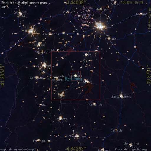
Analysis of Reriutaba night lights 2016
Square area 10x10 km:
 0.87%
0.87%90-99
2.6%80-89
0%70-79
1.52%60-69
0.65%50-59
0.87%40-49
0.65%30-39
0.65%20-29
0%10-19
2.6%0-9
89.61%Square area 50x50 km:
0.25%90-99
0.72%80-89
0.22%70-79
0.49%60-69
0.68%50-59
0.69%40-49
0.76%30-39
0.45%20-29
0.74%10-19
0.76%0-9
94.23%Clear (daylight) street map image can be seen on geolist.org.
Map coordinates:
3° 26' 24.3" South, 41° 17' 7.3" West
4° 8' 30" South, 40° 34' 56" West
4° 50' 33.5" South, 39° 52' 44.8" West
Some cities around Reriutaba sort by population:
• Ipu
24.6 km =15.3 mi,  215°
215°
• Santa Quitéria
51.7 km =32.1 mi,  114°
114°
• Guaraciaba do Norte
18.5 km =11.5 mi,  261°
261°
• Varjota
13.1 km =8.1 mi,  116°
116°
• Ubajara
49.3 km =30.6 mi,  310°
310°
• Hidrolândia
33.7 km =20.9 mi,  151°
151°
• Ibiapina
41.8 km =26 mi, 305°
• Cariré
24.4 km =15.2 mi,  29°
29°
3390659 (p: 12,076)
Sources (retrieved 2019-11-25):
» Earth at Night: Flat Maps 2012, 2016