Quebrangulo night lights from space
Night Light of Quebrangulo (Alagoas) from space (Brazil) Src. Average luminocity for 10x10km area is 9.2532% and for 50x50km: 6.2284%.
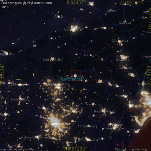
Analysis of Quebrangulo night lights 2016
Square area 10x10 km:
 0.43%
0.43%90-99
2.6%80-89
1.3%70-79
0.87%60-69
0%50-59
2.81%40-49
1.3%30-39
1.08%20-29
0.43%10-19
0.87%0-9
88.31%Square area 50x50 km:
0.33%90-99
0.74%80-89
0.59%70-79
0.74%60-69
0.82%50-59
1.27%40-49
1.45%30-39
1.27%20-29
2.1%10-19
4.55%0-9
86.14%Clear (daylight) street map image can be seen on geolist.org.
Map coordinates:
8° 37' 27.7" South, 37° 10' 27.3" West
9° 19' 8" South, 36° 28' 16" West
10° 0' 43.3" South, 35° 46' 4.8" West
Some cities around Quebrangulo sort by population:
• Bom Conselho
28.3 km =17.6 mi,  305°
305°
• Viçosa
25.9 km =16.1 mi,  103°
103°
• Cajueiro
44.3 km =27.5 mi,  177°
177°
• Maribondo
34 km =21.1 mi,  147°
147°
• Anadia
44.6 km =27.7 mi,  155°
155°
• Igaci
30.1 km =18.7 mi,  216°
216°
• Santana do Mundaú
32.1 km =19.9 mi,  58°
58°
• Taquarana
36.4 km =22.6 mi, 184°
3391090 (p: 6,587)
Sources (retrieved 2019-11-25):
» Earth at Night: Flat Maps 2012, 2016